Everything needed for interplanetary navigation. Instrument to determine the ship's current trajectory and calculating devices to plot new trajectories.
There are many navigational instruments.
A periscope sextant to take navigational readings, with its azimuth ring. (In THE REVOLT ON VENUS, this is what Roger Manning was looking through when he noticed the atomic bomb attached to the Polaris' tail) There also might be a goniometer, which is used to measure angles. A good-sized telescope, either in a dome or with a coleostat. (The periscope, the telescope, or both will be equipped with a filar micrometer.)Star trackers, star scanners, solar trackers, sun sensors, and planetary limb sensors and trackers. Inertial tracking repeaters (note that the inertial tracker platform will have to be manually realigned every twelve hours because it tends to drift. The star tracker is used for reference.). There might even be a pulsar positioning system.
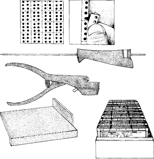
In addition to navigational instruments there will be other necessary gear. There will be an incredibly precise chronometer. An integrating accelerograph (displaying elapsed time, velocity, and distance in dead-reckoning). An indicator of the spacecraft's current mass ratio. An integral audio recorder and a log book for radio messages and navigational fixes.
Not to mention lots of paper, pencils, slide rules, and ballistic calculators. Or instead of all this junk they may have a smartphone with an AstrogateMeTM app.
Secondly, readouts for the ship's navigational and tactical sensors. The big radar scope. Doppler radar and radar altimeter. This might be a separate deck, if you think it is insane to have a single crewperson responsible for navigation, detection, and communication like in Tom Corbett Space Cadet.
Thirdly communicationgear, perhaps even with something like a Morse code key for use when radio interference becomes a problem (If this was a Metalunan ship, this is where you'd find the interociter).
There might be a separate communications deck, which is generally called a "radio shack", crewed by a communication officer whose nickname is "Sparks." If this is a military spacecraft this might be the place for the safe containing the code book. Hit the red "incinerate" button to keep the one-time pad and Captain Midnight secret decoder ring from falling into enemy hands. On some ships this safe might be in the captain's cabin.
In a science-fiction universe with Discontinuous ("teleport-like" or "jump") faster-than-light drives in their starships, traditionally the astrogator's job after each instantaneous jump was to establish the location the starship materializes at, with micrometer precision. This has to be done before the astrogation calculation for the next jump can be performed (for each jump you have to know where you are starting from). This is usually done by using spectroscopy to identify three or more stars, to locate the starship's position by triangulation.
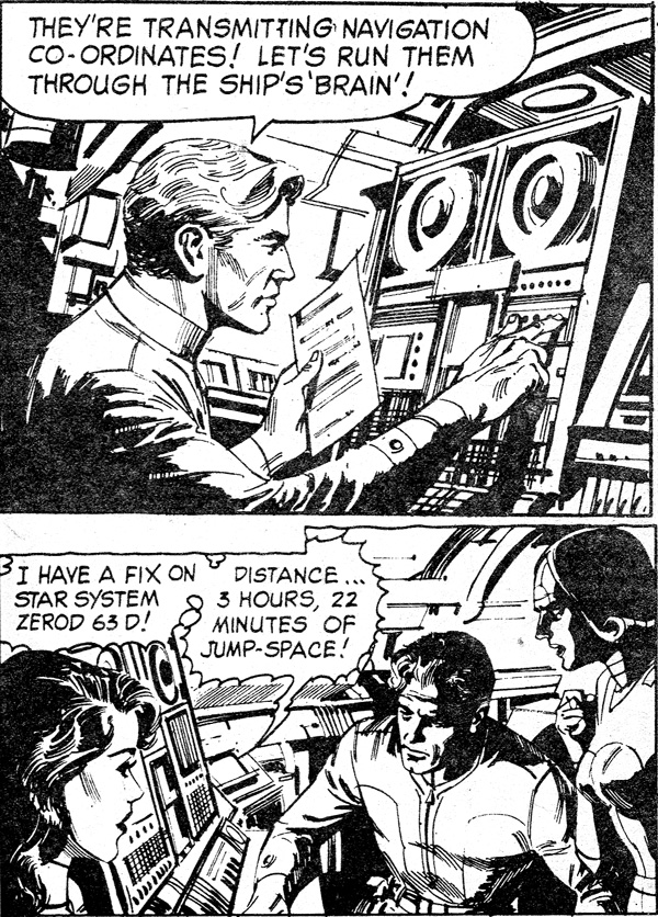
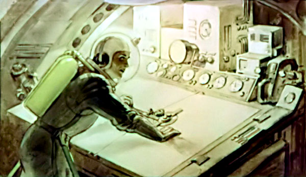
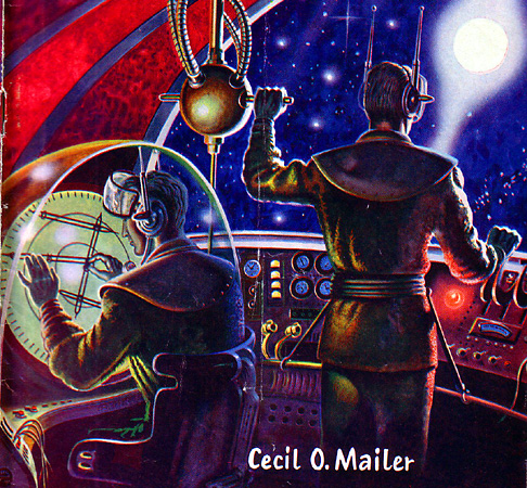
"I'm ready now, sir," replied Roger calmly. He turned to the swivel chair located between the huge communications board, the adjustable chart table and the astrogation prism. Directly in front of him was the huge radar scanner, and to one side and overhead was a tube mounted on a swivel joint that looked like a small telescope, but which was actually an astrogation prism for taking sights on the celestial bodies in space.
From STAND BY FOR MARS by Carey Rockwell (1952) a Tom Corbett Space Cadet novel
Review of Interplanetary Navigation
Interplanetary flight requires the early accumulation of data having a high degree of accuracy for prediction of flight path and velocity. Because the requirements on accuracy are great, it is imperative that every source of information be utilized in an optimum manner. During such flights Earth-based tracking should be employed as much as possible, and use made of onboard observation for augmentation. Both automatic and astronaut observations must be considered for the latter.
Onboard navigation requires precision angular measurements between stellar and planetary objects. These measurements are referenced to an inertial measurement unit, a stable platform mounting accelerometers, and gyroscopes, and are processed in a computer employing techniques which enable the determination of the orbit and its predictions at some future time. The onboard observations can be performed automatically or manually. Two types of such observations can be made:
An angular measurement between a star and a planet
An angular measurement of the angle subtended by a planet
The types of guidance equipment that can be expected are as follows:
Inertial Measurement Unit: A stable platform mounting three accelerometers and, in one configuration, a space sextant. The IMU would be updated by stellar sightings, and would provide the crew with an attitude reference as required.
Space Sextant: A two or three telescope sextant capable of subtense and stadiametric measurements.
Acquisition Telescope: A wide field of view telescope used for coarse pointing of the sextant.
Radio Tracking Subsystems: Subsystems to determine coordinates with respect to the Earth, altitude with respect to Mars and requisite rendezvous and tracking radars operating with the DSIF link as appropriate.
Guidance and Navigation Computer: Advanced digital computer using redundancy concepts to achieve reliability.
Interface Equipment: Input-output devised for coordinating the operation of the sensor subsystems, the computer and the displays. Interface equipment will also be required for reading in spacecraft status measurements and crew guidance commands. Outputs to the communication system are also desirable.
An important part of a study of interplanetary guidance requiring a high degree of accuracy is the development of a realistic observation error model, which describes statistically both the random and systematic errors that can be expected with each observation. The observations, of course, are angular measurements of a star or a planet referenced to the IMU or an angular measurement of the angle of subtense of a planet. In an uncrewed or automatic system, horizon scanners and star trackers comprise the basic units employed during this operation. The accuracies of these instruments anticipated for the era of 1971 to 1986 are discussed below.
The horizon scanner to be used during this application would operate in the infrared portion of the spectrum, obviating problems associated with partial illumination. A major problem with this instrument is its relative inaccuracy, which is due first to basic instrument uncertainties and second to uncertainties that exist in the planet horizon as seen by the scanner.
One of the advantages of this instrument is its capability of measuring the angle subtense to a planet. If the radius of the planet is known, the distance to the planet can be inferred directly.
The accuracy of altitude information obtainable with this instrument decreases with distance from the planet. With adequate instrument design usable information should be obtainable out to approximately 100 planetary diameters.
Beyond the useful operating distance of a horizon scanner, it becomes necessary to use an instrument similar to a star tracker for planetary observations. This instrument is sensitive to the visible portion of the spectrum. It is anticipated that pointing errors due to partial lighting of the planet can be compensated for in the computer.
In addition to planetary measurements, it is necessary to observe stellar objects. For this a star tracker or a sun tracker must be used. When more than one star is to be observed, the star tracker can be programmed from one to another making sequential observations.
Jim Lovell mans the Command Module's Guidance and Navigation station during Apollo 8 NASA
How a tool from the Age of Discovery found use in the Space Age
Over the course of a decade, the Apollo program (in addition to landing humans on the Moon six times!) produced an incredible array of technical breakthroughs and achievements. But many people do not know that in addition to the army of NASA employees who worked the missions, the truly miraculous Apollo Guidance Computer (AGC), and the worldwide network of tracking stations that helped the astronauts get to and from the Moon, a device descended from antiquity was included aboard the Command Modules to assist with guidance and navigation: a sextant.
A traditional sextant, such as the type that might be used on sailing vessels USGS Museum Staff, United States Geological Survey
Sextant basics
Sextants measure the angular distance between two different objects — usually distant stars, although on Earth the Sun and Moon can be used as navigational aids as well. Information derived from sextants can be used to identify one’s position on a map or chart and is vitally important when no land is in sight. Sextants were widely adopted after their introduction in the 1700s, as they could be used day or night and operated even aboard a shifting or unstable platform. Sextants have been used for centuries on Earth, usually aboard ships at sea, but they function aboard aircraft as well (early versions of the venerable Boeing 747 even came equipped with a sextant port for making optical sightings). From a practical point of view, sextants require no power and work independently of other navigational systems, and as such can be employed as a failsafe if electrical power and/or communications fail. The Apollo sextant played just this role, working with the AGC and often functioning as a navigational aid. Ground-based personnel compared their computed results to those obtained via the sextant as a further backup.
The Apollo sextant combined two separate optical devices that worked in conjunction as a functioning sextant: a 1x wide-field telescope (which was used to identify a target constellation or a single star) and a 28x telescope (which was used to make the actual angular measurement). Based on this measurement, which was extremely precise, the AGC could then compute the position of the Command Module based on previously stored data. Over the course of an entire mission, constellations, stars, Earth, and the Moon itself were all targets of the sextant.
An Apollo sextant on display in the National Air and Space Museum Doug Adler
A multipurpose tool
The Apollo sextant was used in Earth and lunar orbit, as well as while en route between Earth and the Moon. It played different roles in each of those contexts: in orbit around Earth or the Moon, the sextant could be used to compute the spacecraft’s altitude and position; whereas in transit between Earth and the Moon, it could be used to compute the spacecraft’s attitude (orientation), position, and velocity. A proper attitude during the flight to and from the Moon was critical for accurate course corrections and burns to reach the Moon and correctly insert the spacecraft into the desired lunar orbit.
The device was used repeatedly throughout the Apollo program across many phases of the missions, up to and including re-entry. Although all Apollo astronauts trained to some extent in the use of the sextant, it was perhaps most famously used by Jim Lovell aboard Apollo 8 during its circumlunar flight. The device was integrated into the manned spaceflight program before NASA realized how much the astronauts would depend on help from ground crew and at a time when there were real fears about the Soviet Union trying to “jam” communications between Ground Control and the astronauts to foul a space mission.
(While it may seem silly to think this way now, it’s worth remembering that the Space Race took place at the very height of the Cold War, when such concerns were widespread and taken very seriously.)
The sextant could also be used as a simple telescope when needed. In July 1969, Michael Collins tried — without success — to use the Apollo 11 sextant to find the Lunar Module Eagle in the Sea of Tranquility after landing. His failure probably stemmed from the fact that Neil Armstrong had piloted the craft to a site about four miles (six kilometers) from the intended landing zone. In November 1969, during the Apollo 12 mission, Richard Gordon was able to use the 28x telescope portion of the sextant in the Command Module Yankee Clipper to clearly see the,Lunar Module Intrepid and the nearby Surveyor probe in the Moon’s Ocean of Storms after Pete Conrad and Alan Bean landed.
While manned missions to the Moon or even Mars are years away, it seems likely that future astronauts traveling to these destinations would be wise to bring along a sextant given the accuracy, ease of use, and value of such a device in addition to whatever other technology they carry with them. Sometimes the old ways really are the best.
ESA astronaut Alexander Gerst learns how to use a sextant. “I learned how to navigate after the stars using a sextant,” said Gerst. “It’s actually a test for a backup nav method for Orion & future deep space missions.” Credits: NASA
A tool that has helped guide sailors across oceans for centuries is now being tested aboard the International Space Station as a potential emergency navigation tool for guiding future spacecraft across the cosmos. The Sextant Navigation investigation tests use of a hand-held sextant aboard the space station.
Sextants have a small telescope-like optical sight to take precise angle measurements between pairs of stars from land or sea, enabling navigation without computer assistance. Sextants have been used by sailors for centuries, and NASA’s Gemini missions conducted the first sextant sightings from a spacecraft. Designers built a sextant into Apollo vehicles as a navigation backup in the event the crew lost communications from their spacecraft, and Jim Lovell demonstrated on Apollo 8 that sextant navigation could return a space vehicle home. Astronauts conducted additional sextant experiments on Skylab.
“The basic concepts are very similar to how it would be used on Earth,” says principal investigator Greg Holt. “But particular challenges on a spacecraft are the logistics; you need to be able to take a stable sighting through a window. We’re asking the crew to evaluate some ideas we have on how to accomplish that and to give us feedback and perhaps new ideas for how to get a stable, clean sight. That’s something we just can’t test on the ground.”
The investigation tests specific techniques, focusing on stability, for possibly using a sextant for emergency navigation on space vehicles such as Orion. With the right techniques, crews can use the tool to navigate their way home based on angles between the moon or planets and stars, even if communications and computers become compromised.
“No need to reinvent the wheel when it comes to celestial navigation,” Holt says. “We want a robust, mechanical back-up with as few parts and as little need for power as possible to get you back home safely. Now that we plan to go farther into space than ever before, crews need the capability to navigate autonomously in the event of lost communication with the ground.”
Early explorers put a lot of effort into refining sextants to be compact and relatively easy to use. The tool’s operational simplicity and spaceflight heritage make it a good candidate for further investigation as backup navigation.
Jim Lovell demonstrated on Apollo 8 that sextant navigation could return a space vehicle home. Credits: NASA
Video Clip "Navigating Space by the Stars" click to play video
Artwork by Kurt Röschl, for Erich Dolezal: Raumflotte I (1952)
Astrodome
Artwork by Fred Freeman
Many of the navigational instruments might be mounted inside an "astrodome", which is a blister dome of some strong but transparent material used with a manual sextant as a back-up to the periscope. (Note that astrodomes cause optical distortion that need a mathematical correction.)
If there is an astrodome, the room will have alternative lighting that is all red, like a darkroom. This is to preserve night vision. It should also have a retractable shield. This is to preserve day vision in case the rotation of the ship moves the eye-destroying fury of the Sun into view. The shield is not only useful to keep sunlight out, but to keep the atmosphere in, in case the astrodome is breached or shattered. Not to mention protecting the astrodome from melting if the ship does some aerobraking in a planetary atmosphere.
Moonbus cockpit from 2001, note red cockpit lighting
Aries 1B from 2001, note red windows.
If the ship spins on its axis for artificial gravity, it might be a good idea to locate the astrodome in the nose of the ship, i.e., at the center of the axis of rotation. A tiny room with the astrodome in it could be counter-spun. So while the ship was spinning, the room would be stationary, freeing the astrogator from the difficulty of making observations of a sky that is madly spinning about. The problem is that if this is a nuclear powered ship, the docking port has to be on the nose. It is possible to rig in a coleostat a shutter that is synchronized with the spin of the ship. This will provide a stroboscopic but steady image if you cannot counter-spin the astrodome.
If the ship is advanced enough to have an actual centrifuge, instead of spinning the entire ship, things will be easier. Just make sure the astrodome is on the stationary part of the ship.
SPACE ANGEL
"Well, it's just that, here I am in space, and I haven't seen space yet. I mean, not space, but the stars, and, you know—what I guess I'm saying is, is there a window or porthole or something on this ship? So far, it's like being in a building; just not very real. If I could just see the stars, I'd know I was really here."
"Why, to be sure," Finn said, "there's an old navigator's bubble that opens off my instrument compartment. When the Space Angel was built, it was still required that there be a place where the navigator could take visual sightings if the instruments failed, though I never heard of such things being any use for charting a course in deep space. When you've finished your galley chores, drop in and I'll open her up. I've not had a look at the stars in a score of voyages."
"I'll be along too, if you don't mind," Bert said. "It would be nice to resurrect the old thrill of being in space. At my age, such nostalgia has a rejuvenating effect."
In all, eight of the ship's company showed up at the observation bubble. A circular area five meters in diameter, its instrument consoles had long since been ripped out, and the air was musty with disuse.
From SPACE ANGEL by John Maddox Roberts (1979)
THE FOREVER WAR
The bridge looked like any other computer facility; they had dispensed with the luxury of viewscreens. We stood at a respectful distance while Antopol and her officers went through a last series of checks before climbing into the tanks and leaving our destiny to the machines.
Actually, there was a porthole, a thick plastic bubble, in the navigation room forward. Lieutenant Williams wasn’t busy, the pre-insertion part of his job being fully automated, so he was glad to show us around.
He tapped the porthole with a fingernail. ‘Hope we don’t have to use this, this trip.’
‘How so?’ Charlie said.
‘We only use it if we get lost.’ If the insertion angle (into the collapsar stargate) was off by a thousandth of a radian, we were liable to wind up on the other side of the galaxy. ‘We can get a rough idea of our position by analyzing the spectra of the brightest stars. Thumbprints. Identify three and we can triangulate.’
‘Then find the nearest collapsar and get back on the rack,’ I said.
‘That’s the problem. Sade-138 is the only collapsar we know of in the Magellanic Clouds. We know of it only because of captured enemy data. Even if we could find another collapsar, assuming we got lost in the cloud, we wouldn’t know how to insert.’
‘That’s great.’
From THE FOREVER WAR by Joe Haldeman (1975)
Astrodome. Artwork by Fred Freeman
Artwork by Kurt Röschl, for Erich Dolezal: Raumflotte I (1952)
Astrodome. Artwork by Jerry Robinson
Astrodome. The three tiny hemispheres on top of dome are star trackers. Astrogator's chair and telescope array rotates around vertical axis azimuth, the telescopes rotate around horizontal axis for elevation. Artwork by Fred Freeman.
Astrodome is faintly visible behind the astronauts. Artwork by Fred Freeman.
click for larger image
detail
Astrogation Calculation
Astrogators have two main jobs:
Orbit Determination: Knowing the spacecraft's current position and velocity, and predicting future position and velocity.
Flight Path Control: Calculating maneuvers for the pilot to alter the spacecraft's trajectory in the desired direction.
The astrogator is responsible for offering the Captain a range of solutions for the mission the captain orders, plotting the course for the chosen solution, giving the pilot the specifications for the required maneuvers needed to implement the course, and to monitor the progress of the spacecraft along the course while calculating mid course corrections for the pilot in order to keep the ship in the groove.
Nowadays there will be no astrogator. The captain will type the desired mission into their cell phone's astrogator/pilot app and let it do all the math and ship piloting. From an author's point of view this is a disaster due to Burnside's Zeroth Law. One possible solution is to make the personnel on the spacecraft not be "crew" so much as system managers. Rick Robinson points out that you'll need a human astrogator if something drastically unexpected happens. For instance, if the unexpected arrival of a Klingon invasion fleet unexpectedly overlaps the optimal trajectory delivered by the astrogation computer.
Hard SF: So Hard It's Impossible ...?
(ed note: "Asgard's worry gang" is a reference to the novel Starman Jones by Robert Heinlein)
What the control room crew does on watch, however, is probably not just a jazzed up version of the Enterprise bridge crew or the Asgard's worry gang. (Off watch is another matter, humans being humans.) Computers will indeed do nearly all the piloting and navigating in the usual sense — handflying a spaceship is a ding waiting to happen, as the Mir-Progress collision already demonstrated. So what are the people doing?
Oddly enough we are very hazy on that, or at least I am. I imagine much of their duties will involve monitoring and controlling the computers that actually fly the ship — maintaining software and the like, but especially performing tasks such as simming possible future maneuvers. More direct intervention will be called for only in circumstances that fall outside the flight plan, including all precomputed variations. Which is a technical way of saying "story conditions" — because if your story involves the control crew in their professional capacity, it is a pretty good bet that the ship's regular flight plan is about to get nullified.
As for the part that intuition might play in all this, in skills like navigation, intuition is what you fall back on when the problem you need to solve is not in the manual. (Or, as in Starman Jones, when the manual has been disappeared.) It may be worth noting here that computer programming itself is a notoriously intuitive art, filled with what programmers themselves call deep magic — which is why there are still so many rich geeks in Silicon Valley. No one has yet managed to automate software design, and few are holding their breath for it.
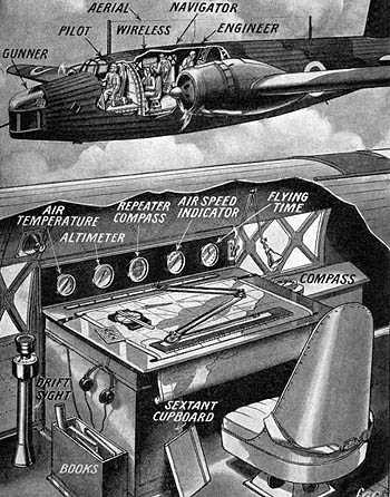
“ONE OF THE most important members of a combat crew
assigned to an airplane is the navigator. No matter how
good the pilot or the bombardier, no long-range mission
can be accomplished without a competent navigator. These missions have to be carried out by day or night over land or water
and only by accurate navigation can the mission be accomplished.”—from a statement issued by the Office of the Chief of
the Air Corps.
Memo to the Future
THE QUOTATION above is an extract from a form letter that
had been widely circulated by the United States Army Air Corps.
Today first-class navigators are in demand as never before. Men
who prepare for battle by learning about the altitude of Dubhe,
the declination of Mars, and the hour angle of the Vernal Equinox. Their names may never loom large in the headlines, but
when history was being made over Tokyo they had their share
in the making of it. It is the writer’s considered opinion that some day—one thousand or ten thousand or as many years from now as you like—a
letter essentially identical with the one quoted here is going to
be written. Change “airplane” to “spaceship” and “land or water”
to “planet or satellite” and this one could be filed away for
future reference. Without the slightest desire to enter into competition with Nostradamus and other professionals in the prophecy business, nothing could seem more certain that when space
flight does come there is going to be a crying need for navigators
—beg pardon—astragators. For you just naturally can’t expect to
get to Mars flying by the seat of your pants! Furthermore, it would seem that out of all the various aspects
of space travel—fuel, speed, radius of action, et cetera—on none
may we feel so sure of ourselves as that of astragation. Doubtless
fifty years hence our pictures of rocket craft will look as crude
as the engravings in the Jules Verne books do today. But it is
hard to see how the principles of astragation can differ radically
from the principles upon which nautical astronomy and celestial
mechanics are based. In fact, astragation would appear to he the
one subject we can discuss with confidence while we have yet
to journey a thousand years in time before we reach it.
One reason for being so cocksure on this matter is that nautical
astronomy or celestial navigation is pretty much the same today
as the past century. Most sciences are scarcely recognizable after
a few decades but celestial navigation is pretty much the same
today as when Dewey sailed into Manila Bay. (We are not talking about purely instrumental improvements now.) True, Nathaniel Bowditch with his longitudes by lunar distances and the
moons of Jupiter is definitely out. But many mariners still go
through the bootstrap-raising procedure of finding their latitude
from a meridian altitude of the Sun, which is later used to get
the longitude by a time sight, which is later used to calculate
when the Sun will be on the meridian again. Modern celestial
navigation had its birth little more than a century ago. In the same way that aerial navigation has taken and adapted
to its own special uses the methods of surface navigation, so
undoubtedly space pilots will borrow heavily from substratosphere flight. Hence, perhaps a few words as to how position
is determined upon the Earth may be advisable. The principle
of modern navigation is fortunately very easy to grasp—so easy
that after a little practice you can locate your own back yard
within a few hundred miles from the stars. Most of the great
discoveries of science are hatched quietly in the laboratory or
study after years of patient note taking and experimentation.
The line of position, on the contrary, sprang full-grown from the
elements, an offspring of the lightning and tempest.
The dramatic details follow, and the reader’s indulgence is
asked if the nautical phraseology misses occasionally.
On November 25, 1837, Captain Thomas H. Sumner, an American shipmaster, set sail from Charleston, South Carolina, bound
for Greenock, England. Heavy gales from the westward had
promised a quick passage. But after passing the Azores the wind
prevailed to the southward with thick weather, making observations impossible until soundings indicated the presence of
land. About midnight on December 17th they arrived within
forty miles by dead reckoning (D.R.) off the Irish coast. At dawn no
land was yet in sight but about 10 A.M. the clouds broke for a
few minutes permitting time for an altitude of the Sun to be
taken. Now a single altitude of the Sun cannot be used to get your
longitude unless you already know your latitude. Captain Sumner had gone so long Without observations, however, that he
was well aware his latitude by dead reckoning was likely in
serious error. But as the storm increased in violence he at last
decided in desperation to take a chance and use it anyhow.
Applying the formulas in the usual way he got a longitude fifteen
miles east of his D. R. position. Next he simply assumed two
latitudes ten miles to the north of his D. R. position and toward
the danger. The remarkable fact emerged that when these three
points were plotted upon a chart they fell upon a straight line
that passed through Small’s Light. Fig. 9.
It then became at once apparent that on the observed altitude
must have happened at all three points on the chart, at Small’s
Light, and the ship, at the same instant. Thus, although Captain Sumner did not know his absolute
position, he did know that his ship was somewhere upon this line,
and if he could continue upon it he would eventually reach
Small’s Light. Setting his course accordingly, Small’s Light hove
in sight in less than an hour. Later he found that if the D. R.
latitude alone had been used the result would probably have
been disastrous. The significant feature about Captain Sumner’s discovery—which for some reason he did not get around to publishing until
six years later in 1843—is that when you measure an altitude of
a star it puts you somewhere upon a line and not merely at a
point. Suppose you had a chart giving the position of a buried
treasure. The “gold is buried eighty rods from the old mill down
by the graveyard and seventy rods from the blasted oak across
the way.” With no other information for guidance a large scale
program of excavation would appear to be necessary to locate
the gold. But a little reflection will show that actually its position
is quite definitely fixed. For if a circle is drawn around the old
mill with a radius of eighty rods and another around the blasted
oak with a radius of seventy rods, they will cross at two points.
These two points are the only ones that satisfy all the given conditions; namely, they are both eighty rods from the mill and
seventy rods from the oak tree. Therefore, the treasure must be
under one of them. (See how long it takes your friends to figure
this out.)
Circles of position from observations of two stars. The substellar points are indicated
by crosses. The position of the ship was latitude 17° N, longitude 5 hours
10 minutes west. The position in South America indicated by the other
intersection was obviously not that of the ship (because ships are generally on the ocean, not dry land). The circles are slightly
distorted because they are drawn on a projection map
rather than on a world globe.
WHENEVER you measure the altitude of a star it puts you
somewhere upon a vast circle which is centered around that
point on the Earth where the star is directly overhead—the sub-stellar point. Measure the altitude of another star and it puts you
on a second circle that will always intersect the other at two
places. Since a navigator always knows his position within about
twenty miles or so by D. R. he is never in doubt as to which point
to choose. The simplest way to locate yourself by means of star circles
would be to draw them directly onto the surface of a large globe
and see where they cross. But keeping a large globe always handy
might be somewhat awkward especially within the narrow confines of a bomber. Besides a navigator in the Bering Sea has but
an academic interest at most in that portion of his circle of position that passes through the Caroline Islands, for example. The
navigator always knows his position approximately so that the
only portion of the circle that concerns him is the exceedingly
short section of it in his immediate vicinity. An arc of only a few
miles can be replaced with all the accuracy necessary by a
straight line. Where two such lines cross gives him his “fix.” A navigator on his way from Dutch Harbor for Tokyo would
determine these lines in what at first seems like a curiously
roundabout sort of way. After selecting a suitable star for observation he picks out a point not too far away with a latitude and
longitude that will fit neatly into his tables without having to
bother over interpolating between numbers. (Always a messy
operation even under the best of conditions.) His tables tell him
what the altitude of this star would be if observed from that
particular point. Then he maneuvers the bubble of his aircraft
octant into position and actually measures its altitude. The difference between the hypothetical altitude and the observed altitude tells him how far off he is from his assumed position. So much for the determination of position upon a planet. Now
let us ponder upon the determination of position between planets.
How to get a space fix, in other words. When the writer innocently began to meditate upon this question he was wholly unaware that anyone before him had ever
given such matters really serious consideration. Quite by accident he came across a most interesting book by P. E. Cleator (“Rockets Through Space,” Simon and Schuster)
which contained references to numerous highly technical treaties
on space travel one of which ran into nine volumes of two hundred pages each! Unfortunately or otherwise for interplanetary
enthusiasts in this country, the subject seems to have been developed almost exclusively by Russians, Germans, French, and
Italians who have taken care to see that their published works
are safe from the prying eyes of the laymen. Iudging from Mr.
Cleator’s account, however, practically nothing has been done
toward the specific problem of fixing position in space. Thus he
writes on Page 106: “Determining the exact location of a spaceship in space, even on a lunar journey, will entail complicated
calculations based on the movements of the planets against the
background of the so-called fixed stars.” This is exactly opposite to the conclusion the writer had arrived at, as it would seem to be a comparative easy job to get
a fix in space by calculations no more complicated than many
student navigators are doubtless performing right now. On the
old principle that fools rush in and et cetera, the following is
offered without copyright for the advancement of extra-terrestrial
flight. ONE FACT immediately evident to the most casual observer is
that interplanetary travel is going to be confined almost exclusively to one plane—the plane of the Earth’s orbit. All the planets
except Mercury revolve in very nearly the same plane and since
it is a minor complication that can be easily corrected in practice, let us begin by assuming that the planets never deviate from
the plane of the Earth’s orbit. A spaceship will then seldom
have occasion to dip much above or below this level unless it
be to avoid the zone of asteroids or take a side trip to one such
as Hidalgo whose orbit is cocked up at an angle of forty-three
degrees to it. On this basis only two quantities would seem to be needed
in order to locate an object anywhere within the solar system:
(1), its distance from the Sun; (2), the angle at the object between the Sun and some fixed direction in space. The last may
be an imaginary point like the vernal equinox which astronomers
use so much, or for practical purposes of measurement a bright
star such as Regulus which happens to coincide almost exactly
wilh the plane of our solar system. No instruments would be necessary beyond an ordinary spring-wound chronometer, a device
for measuring angles similar to the present bubble sextant used
by aerial navigators, and a Space Almanac. One sight on a star for
longitude and another on a planet for distance should be enough
to turn the trick. Just as a navigator either by sea or air always knows his posilion approximately, so the astragator will undoubtedly have some
means of keeping track of his whereabouts and use it as a sort
of springboard or jumping-off place for the determination of a
fix in space. There are several ways of approaching the problem but the following would seem to be the simplest and most
natural from the astragator’s point of view. Here is a typical
example stated in Captain Bowditch’s best style:
“In space, on February 9, 5347 at 0645 in D. R. Long. 95°,
Dis. 1.125 A. U. Took simultaneous sights on Sun and Regulus,
ang. dist. 115°; and Sun and Mars, ang. dist. 101°. What was
ship’s position?”
First it should be emphasized that Regulus simply gives us a
direction in space. The star is so tremendously far away that any
two lines drawn from within the solar system toward it are for
all practical purposes parallel. Thus a star which is virtually at
infinity serves to orient the ship in longtitude, or get it located
in space in the right direction from the Sun.
LOOK at the diagram Fig. 11, which shows the true position of
the ship at X and the supposed or D. R. position at X’. (The error
in D. R. is enormously exaggerated for purposes of illustration.)
If the spaceship actually were at X’, then the angle A’ between the longitude of the ship and the longitude of Regulus,
would equal the angle at the Sun between the ship and Regulus.
The astragator cannot measure the angle A’ since there is no
tangible object in space that marks his longitude. But it is possible for him to measure the angle between the Sun and Regulus
and by subtraction from 180° get the difference in longitude
between Regulus and himself. The astragator looks up the longitude of Regulus in his list of
fifty-five astragational stars and finds it to be 150°. His longitude
by D. R. is 95°. Hence the difference in longitude between
Regulus and himself should be 150° less 95° or 55°. Which
means that the angle he can measure should be 180° less 55°
or 125° But as stated in the problem this angle is not 125° but 115°
instead—10° less than the value given by D. R. Now it must be pretty obvious simply from an inspection of
the diagram that under the circumstances if the angle measured
between the Sun and Regulus comes out smaller than the D. R.
value, the ship must be west of the assumed position. (For ex-
ample, if the D. R. position were so far off that it put the ship
on the line drawn from the Sun toward Regulus the measured
angle would be 180°. This would make the ship 180° less 115°
or 65° to the west of the D. R. position.) Therefore, the astragator knows that he is somewhere on a
line 10° to the west of where he thought he was, or in longitude
85° and not 95°. He has now determined his direction from the
Sun, but still is in the dark as to his distance from the Sun. His
next step is to find this quantity. He does this by taking a sight on some body within the solar
system whose position is accurately known. In this case, Mars
happens to be conveniently located for a shot. He measures the
angle between the Sun and Mars of 101°. From the almanac he
finds the distance of Mars for that date is 1:5 A. U. and its longitude 62°. Since he has just found his own longitude, the angle
at the Sun between himself and Mars must be 85° less 62° or 23°. Thus in the Space Triangle—Planet-Sun-Ship—he knows one
side and all the angles which enables him immediately to solve
for his own distance, D. It turns out to be 1.26 A. U., almost
exactly midway between orbits of the Earth and Mars. It should not be supposed that “solving” the Space Triangle
means putting figures into trigonometric formulas. Instead the
astragator will probably press a few buttons on some mechanical
contrivance and watch the answer pop into sight. Celestial navigation demands solution of the so-called “Astronomical Triangle,” and in the days of Moby Dick doubtless many sturdy sailors had their lives shortened more by their struggles with this
three-cornered object than by the old devil sea. The latest tables
issued by the Hydrographic Office—H. O. 214—now makes the
solution of the Astronomical Triangle almost entirely operational,
as easy as dialing a telephone number. THE ACCURACY of much marine navigation is illustrated by
the old story of how third mates after careful measurement put
a dot on the chart that marks the ship’s position. Second mates
draw a circle around the dot. Mates surround the circle with
a free-hand sweep. And the captain lays his hand over the circle
and says, “Somewhere in here!” If skippers in the past have had trouble staying upon their
course, imagine them confronted by a nice little exercise in
celestial mechanics involving the relative positions of their ship,
Sun, and a couple of planets. In the stories, spacecraft seem to
proceed from one point to another by some process of reckoning
such as spinning the bottle or cutting a deck of cards. Seldom
does there appear to be anyone on board who could conceivably solve Kepler’s equation, either drunk or sober. Yet this
is exactly the sort of knowledge anyone will need who plans
to do much roving around our solar system. What might be termed the classical method of reaching Mars
—or any planet for that matter—sounds so easy on paper that
one tingles all over to get started on the trip. Perhaps you have
been laboring all these years under the delusion that we can
never hope to build a cannon big enough to send a projectile to
Mars. Nonsense! The Big Bertha the Gennans used in 1918 was
capable theoretically not merely of sending a projectile to Paris
but all the way to the Red Planet as well. The main requirement in interplanetary communication either
by projectile or rocket is to make sure you have put yourself in
the right orbit at the start of the journey. For once under Way
the rest is easy. You simply shut off the engine, light your pipe,
and let the force of gravitation do the rest. Much space travel
will probably be done by a kind of transorbital coasting or free-wheeling process. A spaceship bound from Greenland, Earth to
Sabaeus Sinus, Mars, should be regarded more as a minor planet
following an orbit imposed upon it, not by some primordial
cataclysm, but rather by some young navigator with a wife and
two children and a down payment on a new stratosphere sedan
coupé. This conception of a spaceship as an asteroid should be clearly
kept in mind. So long as the motors are inactive the ship would
move in the orbit selected for it as obediently as if it had been
following that route for the last hundred million years. Just
because it is passing through unresisting space does not mean
that its motion is uniform, however. As it recedes from the Sun
its speed gradually decreases until the aphelion point is attained.
Then it heads Sunward again at an ever-increasing rate. Unless
the ship should chance to make a very close approach to a
planet, the Sun is always the absolute master.
Pork chop by Winchell Chung jr. Click for larger image
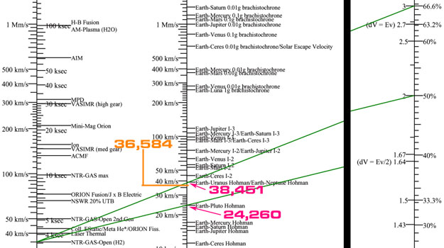
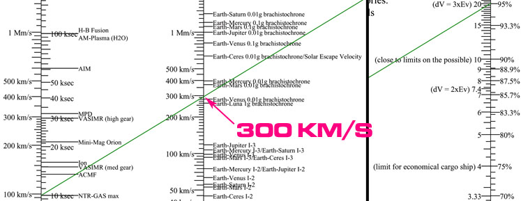
Actual Pork chop from NASA. The important parts to an SF author are C3l[blue] = delta-V for the launch, and TTIME[red] = mission duration. If anybody cares, SEP[green] = Sun-Earth-Probe angle (if too small solar static drowns out probe signal) and Ls[magenta] = Earth-Sun-Mars angle (angle made by drawing a line from Earth to the Sun then to Mars). Click for larger image.
Actually calculating interplanetary trajectories is true rocket science, and beyond the scope of this website (translation: I don't know how to do it). If you simply must know how, a good starting text is Fundamentals of Astrodynamics by Roger Bate, ISBN: 0486600610. The book assumes you are already well versed in calculus.
The captain of the spacecraft will ask the astrogator for a mission plan to travel from point A to point B in time T. The astrogator will determine a family of mission plans, with the current ship's delta-Vcapacity as the upper limit (or the ship will not be capable of performing that mission) and with the captain's specfied mission time as the lower limit (or the captain will be unhappy). You see, a Hohmann trajectory generally uses the least delta-V, but also has the longest possible mission time, and the mission can only start on specific dates ("launch windows") as well. By increasing the delta-V used the mission time can be reduced.
What the astrogator will do is have the navigation computer draw a pork-chop plot, which is a graph with departure times on one axis, arrival times on the other axis, and delta-V requirements drawn as contour lines in the graph. Cross out the areas of delta-V that are too high for the spacecraft, cross out the part of the graph with a mission duration that is too long, what remains are the possible missions.
If it turns out there is no possible mission inside the stated parameters, the astrogator will have to confer with the captain over what is possible.
Example
The Polaris is currently on Terra in the far-flung future time of June 2005. Captain Strong tells astrogator Roger Mannings that he wants a mission plan for the Polaris to travel to Mars. He does not want the transit time to be over 175 days, and the delta-V cost should be below 22,500 meters per second (22.5 km/s).
First Roger has the ship's brain calculate and print out a pork-chop plot for Terra-to-Mars around the current time
Roger eliminates the part of the plot with transit times over 175 days (the gray area above the red 175 day line)
Detail of the allowed part of the plot. Of course, any launch dates that are prior to the current date will also have to be eliminated (unless you have a time machine).
Roger then eliminates the part of the plot with a delta-V requirement over 22.5 km/s (the green area outside the 22.5 contour line)
The white area shows the family of mission plans that fit Captain Strong's specifications. This will give the captain a range of options that can be further narrowed down by optimising for desired launch windows, transit times, etc. For instance, the minimum transit time is at the yellow circle. It will require the full 22.5 km/s delta-V, has a launch window of August 19, 2005, arrival date of January 05, 2006, and have a transit time of 140 days.
Once the specific mission is chosen, with delta-V and duration time, the astrogator does the hard part calculating the trajectory, burn vectors, and check-points. If the SF author wants to go full Heinlein and do that, I refer them to Fundamentals of Astrodynamics or equivalent.
MARS 2020 MISSION DESIGN
(ed note: This is how the pros optimize a mission. You will probably find this to be impenetrable jargon. I have a vague idea of what they are talking about, but there is no way I could actually calculate it.)
Abstract
Following the exceptionally successful Mars Science Laboratory mission which placed the Curiosity rover in the interior of Gale Crater in August 2012, NASA will launch the next rover in the 2020 Earth to Mars opportunity arriving to the Red Planet in February 2021 to explore areas suspected of former habitability and look for evidence of past life. This paper details the mission and navigation requirements set by the Project and how the final mission design and navigation plan satisfies those requirements.
MISSION
Launch
The M2020 flight system will launch in the 2020 Earth to Mars Type 1 opportunity from the Eastern
Test Range (ETR) at Cape Canaveral Air Force Station (CCAFS) in Florida on an Atlas V 541. The
baseline 20-day launch period extends from July 17th through August 5th, 2020. The supplementary 10-day
launch period immediately follows the baseline launch period and extends from August 6th, 2020 through
August 15th, 2020. The supplementary launch period consists of dates with potential launch opportunities
being analyzed for their possible integration into the existing baseline launch period. Viability of any of
these dates depends on launch vehicle performance. Preliminary data indicate that some of these may have
a finite launch window and may be integrated at a later time. All launch days have a constant arrival date of
February 18th, 2021. Launch windows will not exceed 2 hours in duration. Two launch flight azimuths will
be flown across the launch period to maximize launch vehicle performance while satisfying DSN coverage
requirements. The Centaur first burn, which is the longer of the two Centaur upper stage firings, will inject
the vehicle into a 90x137 nmi park orbit inclined at 34.6 deg (July 17th – July 23rd) or 29.2 deg (July 24th –
August 12th). After coasting for 24 to 36 min, the Centaur/spacecraft stack will reach the proper position for
the second Centaur burn to inject the spacecraft onto the desired departure trajectory. The launch window
on any given day during the baseline launch period has a duration between 75 and 120 min. Launch
windows are typically determined by launch vehicle performance and the required injection energy, but for
M2020, shorter launch windows are constrained by the need of having continuous DSN coverage starting at
Separation plus 5 minutes. The launch vehicle injection targets are specified as twice the hyperbolic
injection energy per unit mass (C3), declination of the launch asymptote (DLA), and right ascension of the
launch asymptote (RLA) at the Targeting Interface Point (TIP), defined as Separation plus 4 min. The
injected spacecraft mass is 4,147 kg. Propellant Margin (PM) defined as the additional burnable propellant
beyond the Flight Performance Reserve (FPR), and Launch Vehicle Contingency (LVC), are used to create
daily launch windows.
Interplanetary Cruise and Approach
During the 7-month interplanetary flight of the spacecraft, several major activities are planned
including: up to six Trajectory Correction Maneuvers (TCMs) needed to target to the desired atmospheric
entry aim point at Mars; checkout and maintenance of the spacecraft in its flight configuration; monitoring,
characterization, and calibration of the spacecraft and payload subsystems; periodic attitude adjustments for
power and telecommunications; navigation activities for determining and correcting the vehicle's flight
path; and preparation for EDL and surface operations. Also, during cruise, solar array switching will be
autonomously performed by the flight system. A plot of the heliocentric trajectory for the open of the
launch period is shown in Figure 1.
Figure 1. Interplanetary Trajectory for launch on 07/17/2020 (Launch Day 1)
The launch aimpoint targets are biased away from Mars for planetary protection in order to achieve a
probability of less than 1.0 x 10⁻⁴ of the Centaur upper stage impacting Mars over the next 50 years
(compliance during the first 50 years being a change from the MSL requirement but it is consistent with
Planetary Protection requirements for the Mars InSight mission). All biased injection aimpoints are
designed to target Jezero Crater shown in Figure 2. Planetary protection also requires that the probability of
any anomaly causing impact of the M2020 spacecraft with Mars must be less than 1.0 x 10⁻². This is
referred to as the non-nominal impact probability (NNIP) requirement. Normally, the deterministic ΔV to
remove the injection bias and to perform retargeting is combined with the ΔV to correct launch vehicle
injection dispersions. This is all used to generate the TCM-1 maneuver necessary to target the spacecraft to
the desired Mars atmospheric entry aimpoint. In order to satisfy the non-nominal impact probability
requirement for M2020 the aimpoint for TCM-1 and TCM-2 will be biased away from Mars (for MSL, the
TCM-2 aimpoint was not biased because the calculated non-nominal impact probability during maneuver
design did not violate the Planetary Protection requirements). During operations, it will be determined
whether it is necessary to bias TCM-2 based on orbit determination (OD), probability of spacecraft failure
(Q), and other relevant data. The Cruise phase TCMs are described in Table 1.
Table 1. TCM Profile
MISSION DESIGN
Launch/Arrival Strategy
The M2020 baseline 20-day launch period extends from July 17th through August 5th, 2020. The
supplementary 10-day launch period extends from August 6th, 2020 through August 15th, 2020. Every
launch date has a constant arrival date of February 18th, 2021. The launch/arrival strategy (see Figure 4) is
designed to maximize launch vehicle performance and deliver the flight system to the Martian atmosphere
with entry velocities between 5.2 km/s and 5.6 km/s, while allowing for EDL communication paths via
orbiter relay or Direct-To-Earth (DTE) during Entry, Descent, and Landing (EDL), from atmospheric entry
through landing plus one minute. It is highly desired to have at least two EDL communication paths should
an anomaly occur during this critical event. The Mars Reconnaissance Orbiter (MRO) which successfully
recorded open loop data during the Mars Science Laboratory (MSL) EDL event will again be positioned in
an optimal geometry prior to the arrival of the vehicle to capture the M2020 Ultra-High Frequency (UHF)
signal from a Local Mean Solar Time (LMST) of 3:15 PM. The X-band DTE link adds robustness to the
EDL communication strategy; however, X-band semaphores do not contain telemetry data and are likely to
be insufficient to fully reconstruct most EDL fault scenarios. In the 2020 Earth-to-Mars opportunity, later
arrival dates favor DTE communications; hence, the launch/arrival strategy has the latest arrival date
possible to extend DTE communications while preserving the required launch vehicle performance for a
minimum of 20 continuous launch days. The launch/arrival strategy was selected to maximize DTE
communications (DTE coverage is available from entry through some time after heatshield separation)
while preserving a robust MRO UHF link. This makes EDL communications via an orbiter relay critical
since that path is the only means to obtain EDL data. In addition to MRO, in October 2017, NASA
confirmed that the Mars Atmosphere and Volatile Evolution mission (MAVEN) orbiter will also be
positioned to provide EDL relay communications adding robustness to the EDL communications baseline.
MAVEN executed an inclination change maneuver in July 2018 to change the precession of the orbital
plane to achieve the proper geometry to support the M2020 EDL event in February of 2021. The
launch/arrival strategy figure also shows the regions of full (visibility from Entry to landing plus 1 minute)
MRO and full DTE.
Figure 4. Launch/Arrival Strategy click for larger image
The given mission composed of a series of trajectories. At each point where the spacecraft makes a transition from one trajectory to another is a "maneuver". A maneuver is where the spacecraft uses a burn of its rockets to alter its vector to the new trajectory.
For each maneuver, the astrogator will calculate three maneuver parameters for the pilot:
The Axis of Acceleration (where the ship's nose should be pointing during the burn)
The required amount of Delta V (pilot will figure the proper engine thrust setting and burn duration for this)
The starting time of the maneuver (this should happen at the mid-point of the burn duration, pilot will calculate this. Figure burn duration required for delta V, divide by 2, and subtract from astrogator-supplied maneuver time)
These will be passed to the pilot. If the pilot finds a problem (such as the spacecraft not possessing enough propellant reserves to create the required delta V) they will yell at the astrogator, who will have to frantically recalculate to fix the problem.
ASTROGATION GLOSSARY
Apoapsis In an orbit, the point of the orbit farthest from the astronomical body currently being orbited.
Periapsis In an orbit, the point of the orbit closest to the astronomical body currently being orbited. Some like to replace the "-apsis" part with the name of the body being orbited, but that gets out of hand real quick. For example "perigee", "perihelion", "pericynthion", and zillions of other unwieldy terms.
Prograde In the direction of the spacecraft's trajectory, i.e., "forwards". Fun fact: since the trajectory is curved, prograde is actually at a tangent to the trajectory.
Retrograde In the opposite direction of the spacecraft's trajectory, i.e., "backwards". 180 degrees from Prograde.
Normal At 90 degrees (perpendicular) to the spacecraft's orbital plane, in the orbital "North" direction (using the "right-hand rule").
Anti-normal At 90 degrees to the spacecraft's orbital plane, in the orbital "South" direction. 180 degrees from Normal.
Radial in In the direction of the astronomical body currently being orbited.
Radial out In the opposite direction of the astronomical body currently being orbited. 180 degrees from Radial in.
When planning maneuvers, astrogators will keep in mind the general rules of orbital mechanics.
GENERAL RULES OF ORBITAL MECHANICS
The following rules of thumb are useful for situations approximated by classical mechanics under the standard assumptions of astrodynamics outlined below the rules. The specific example discussed is of a satellite orbiting a planet, but the rules of thumb could also apply to other situations, such as orbits of small bodies around a star such as the Sun.
Orbits are elliptical, with the heavier body at one focus of the ellipse. Special case of this is a circular orbit (a circle is a special case of ellipse) with the planet at the center.
A line drawn from the planet to the satellite sweeps out equal areas in equal times no matter which portion of the orbit is measured.
The square of a satellite's orbital period is proportional to the cube of its average distance from the planet.
Without applying force (such as firing a rocket engine), the period and shape of the satellite's orbit won't change.
A satellite in a low orbit (or low part of an elliptical orbit) moves more quickly with respect to the surface of the planet than a satellite in a higher orbit (or a high part of an elliptical orbit), due to the stronger gravitational attraction closer to the planet.
If thrust is applied at only one point in the satellite's orbit, it will return to that same point on each subsequent orbit, though the rest of its path will change. Thus one cannot move from one circular orbit to another with only one brief application of thrust.
From a circular orbit, thrust applied in a direction opposite to the satellite's motion changes orbit to elliptical; the satellite will descend and reach the lowest orbital point (the periapse) at 180 degrees away from the firing point; then it will ascend back. Thrust applied in the direction of the satellite's motion creates an elliptical orbit with its highest point (apoapse) 180 degrees away from the firing point.
The consequences of the rules of orbital mechanics are sometimes counter-intuitive. For example, if two spacecraft are in the same circular orbit and wish to dock, unless they are very close, the trailing craft cannot simply fire its engines to go faster. This will change the shape of its orbit, causing it to gain altitude and actually slow down relative to the leading craft, missing the target. The space rendezvous before docking normally takes multiple precisely calculated engine firings in multiple orbital periods requiring hours or even days to complete.
To the degree that the standard assumptions of astrodynamics do not hold, actual trajectories will vary from those calculated. For example, simple atmospheric drag is another complicating factor for objects in low Earth orbit. These rules of thumb are decidedly inaccurate when describing two or more bodies of similar mass, such as a binary star system (see n-body problem). Celestial mechanics uses more general rules applicable to a wider variety of situations. Kepler's laws of planetary motion, which can be mathematically derived from Newton's laws, hold strictly only in describing the motion of two gravitating bodies in the absence of non-gravitational forces; they also describe parabolic and hyperbolic trajectories. In the close proximity of large objects like stars the differences between classical mechanics and general relativity also become important.
Burning with the axis of acceleration pointed in the prograde direction ("burning prograde") will expand the size of the orbit. Burning retrograde will contract the size of the orbit. In both cases, the point on the orbit the spacecraft is currently occupying stays put, that is the center point of the orbit expansion/contraction. Usually the burns are done when the spacecraft is at either the periapsis point (closest to the planet) or the apoapsis point (farthest from the planet).
In the diagrams below please remember that Rockets Are Not Arrows. The spacecraft does not have to travel in the direction the nose is pointing, like aircraft do. For instance, in the Burning "Retrograde at Periapsis" diagram below, the spacecraft is traveling counter-clockwise even though its nose is pointed clock-wise and flames are shooting out its rear. The thrust is slowing the ship down, not forcing it to move clock-wise.
Burning prograde at periapsis will raise your apoapsis (move it farther away from planet). Burning retrograde at periapsis will lower your apoapsis (move it closer to the planet).
POLARIS starts at Periapsis, orbiting Terra in a counter-clockwise direction PROGRADE: direction ship is orbiting in RETROGRADE: opposite direction PERIAPSIS: orbit's closest approach to planet APOAPSIS: orbit's farthest retreat from planet
Burning Prograde at Periapsis will raise Polaris' apoapsis. New orbit is the red orbit.
Periapsis does not rise nor fall
Burning Retrograde at Periapsis will lower Polaris' apoapsis. New orbit is the blue orbit.
Periapsis does not rise nor fall
Burning prograde at apoapsis will raise your periapsis. Burning retrograde at apoapsis will lower your periapsis.
POLARIS starts at Apoapsis, still orbiting counter-clockwise
Burning Prograde at Apoapsis will raise Polaris' periapsis. New orbit is the red orbit.
Apoapsis does not rise nor fall
Burning Retrograde at Apoapsis will lower Polaris' periapsis. New orbit is the blue orbit.
Apoapsis does not rise nor fall
This works if you burn at other points in the orbit besides apoapsis and periapsis, but you'll probably only be using apo and peri. Unless you work at NASA or play a lot of Kerbal Space Program. The general rule is that if you burn prograde at a given point in the orbit, the point in the orbit on the exact opposite side of the planet will increase its orbital radius by the maximum amount, and the points in between will increase their radii by lesser amounts, shading down to an increase of zero at the ship's location.
You "circularize" an orbit by making the periapsis and apoapsis the same distance from the planet, i.e., you make the orbital eccentricity close to zero, thus making the orbit a circle instead of some kind of egg shape.
THREE PHASES OF A HOHMANN BURN 1: Trans Mars Insertion (TMI) COAST PHASE BURN 2: Mars Orbital Insertion (MOI)
Superior Martian orbit is the destination orbit
What Is This Used For?
The main use is Changing Orbits. And the most important example of changing orbits is using a Hohmann transfer to another planet.
If the destination orbit is farther from the primary than the starting orbit (technical term is "superior", Mars' orbit is superior to Terra's):
BURN 1: Move your current apoapsis outward until it touches the destination orbit by burning prograde at periapsis. Your orbit has been altered into a Transfer Orbit. You have departed from your starting planet and are en route to your destination.
COAST PHASE: Coast until you reach new apoapsis
BURN 2: Circularize your orbit by moving your current periapsis outward until it also touches the destination orbit by burning prograde at apoapsis. You have matched the Solar orbit of the destination planet. You will have to burn just a little bit more to start orbiting the planet instead of Sol.
If the destination orbit is closer to the primary than the starting orbit ("inferior orbit"), you do the inverse:
BURN 1: Move current periapsis inward until it touches the destination orbit with a retrograde apoapsis burn. Your orbit has been altered into a Transfer Orbit
COAST PHASE: Coast until you reach the new periapsis
BURN 2: Circularize your orbit by moving current apoapsis inward until it also touches the destination orbit by burning retrograde at periapsis
Matching Velocity
When trying to rendezvous with a spacecraft or space station, you have to match the position, vector, and velocity. Matching the velocity is a little counter-intuitive. The technical term is "orbital phasing".
Every object in a given circular orbit is moving at the same speed. So if the Polaris is in a 400 km circular orbit 1,000 km behind a Blortch warship in the same orbit, it will never catch up and will never be left behind. It will eternally be 1,000 km behind.
The Polaris will never catch up if they both are in an elliptical orbit either. They will move at different speeds at different parts of the orbit, but always at the same speed at a given point in said orbit so it all evens out. For instance when the Polaris passes through apoapsis it will be moving at the same speed as when the Blortch moves through apoapsis.
The point being: for the Polaris to move faster than the Blortch warship it has to contract the radius of its orbit (lower the altitude). To move slower than the Blortch, the Polaris has to expand the radius of its orbit (raise the altitude).
Here's the confusing part: to lower the altitude of the orbit (thus increasing your orbital velocity) you have to burn retrograde. Burning retrograde means you are slowing down, since you are thrusting contrary to your orbital vector. See the confusion? To speed up, you slow down. Actually, burning retrograde means you are contracting your orbital radius but using naive reasoning it sure looks like you are putting on the brakes.
So here's the deal: the Polaris burns retrograde into a lower orbit than the Blortch, circularizing the orbit at the desired orbital speed.. It moves faster in this orbit, thus catching up with the Blorch. When the Blorch is almost "overhead" (i.e., on a line connecting the planet's center, the Polaris, and the Blorch) the Polaris burns prograde into a higher orbit then circularizes, matching the orbital radius of the Blortch orbit.
CATCHING AN EGG ON A PLATE
A daisy-clipping orbit of Luna (assuming that Luna has daisies, which seems unlikely) takes an hour and forty-eight minutes and some seconds. Golden Rule, being three hundred kilometers higher than a tall daisy, has to go farther than the circumference of Luna (10,919 kilometers), namely 12,805 kilometers. Almost two thousand kilometers farther — so it has to go faster. Right?
Wrong. (I cheated.) The most cock-eyed, contrary to all common sense, difficult aspect of ballistics around a planet is this: To speed up, you slow down; to slow down, you speed up.
I'm sorry. That's the way it is. We were in the same orbit as Golden Rule, three hundred klicks above Luna, and floating along with the habitat at one and a half kilometers per second (1.54477 k/s is what I punched into the pilot computer … because that was what it said on the crib sheet I got in Dockweiler's office). In order to get down to the surface I had to get into a lower (and faster) orbit … and the way to do that was to slow down.
Burning radial in (towards the primary) or radial out (away from the primary) will spin the entire orbit in place. This only has a noticable effect if the orbit is egg shaped. The orbit can only be spun a maximum of 90 degrees clockwise or counterclockwise. These burns are not used very much, since it is almost always more efficient to use prograde / retrograde burns to do the same thing.
MATCH ORBITAL INCLINATION
If your orbital plane is tilted at a different angle with respect to the desired new orbital plane, you will have to match orbital inclination. This is the first step to making a rendezvous with a planet or docking with another spacecraft. This is also notoriously the most expensive maneuver in terms of delta V.
Where the two orbital planes cross each other are two "nodes", the ascending node and the descending node. At either of the nodes, you burn normal or anti-normal (depending upon the angle of the new orbital plane with respect to the old one, at that node). "Normal" means "at 90° to the orbital plane, in direction of right hand rule." After burning an exorbitant amount of propellant, you will have changed to the destination plane.
PLANETARY RENDEZVOUS or SPACECRAFT DOCKING
The procedure is much the same whether one is trying to leave an interplanetary trajectory to enter orbit around a planet or trying to dock to another spacecraft in orbit around the same planet as you are. In the first case the "target" is the orbit around the planet, in the second case the target is the ship one is docking to.
The goal is for your spacecraft to match both the target's position and vector. That is, you want to be at the target spacecraft or planet's location, moving at the same velocity and in the same direction.
When you arrive at the tangent point and the target, change orbit shape to match the target's orbit. When making a planetary rendezvous, your spacecraft will commonly have lots of velocity that has to be gotten rid off. Often aerocapture is used to avoid having to burn lots of expensive propellant.
However, if the maneuver is a spacecraft docking, you will fail the rendezvous if you do not take into account the complicated interplay of tidal, Coriolis, and centrifugal forces acting upon the docking spacecraft. The linked paper ("The Delicate Dance of Orbital Rendezvous") goes into these in excruciating detail, including lots of ferocious equations with nasty pointed teeth. If you do read the paper, don't miss section III: The Stranded Astronaut.
Altering the spacecraft's trajectory so that the periapsis is inside the atmosphere of the planet being orbited. The spacecraft will slow down due to atmospheric drag. The general rule is that aerobraking can kill a velocity approximately equal to the escape velocity of the planet where the aerobraking is performed (10 km/s for Venus, 11 km/s for Terra, 5 km/s for Mars, 60 km/s for Jupiter).
Can be a prelude to landing, can also be used to slow the spacecraft into a capture orbit ("aerocapture") without having to expend any expensive propellant.
Warning: if the drag and/or heat from friction becomes too strong, bits of the spacecraft will be torn off or melted away. If the drag becomes monstrously strong the entire spacecraft will be shredded or melted away. If you have an astrodome, be sure to protect it by closing the retractable shield. The plasma sheath of ionized atmosphere will cut off radio communcation.
ASTROGATION USER INTERFACE
Video tutorial about Kerbal Space Program orbital maneuvers, by pebblegarden
To get an idea of what the bare minimum is, we will unashamedly be taking a good look at the solution in the computer game Kerbal Space Program. Since that is a game, the designers were forced to distill the controls to the very essentials (because the players will quickly get fed up and leave if they think the game is too complicated). As a matter of fact, that game is so wonderfully educational yet fun, you might be better off if you skipped this section of the website and instead started playing the Kerbal game.
The science fictional astrogation user interface an author invents for their novel does not have to look anything like this. But it does have to offer the same options and functionality.
In Kerbal Space Program there is a solar system map display. This displays the planets in their orbits and the ship in its trajectory (including altitude, position and time of apoapsis and periapsis). To create a maneuver, the player/astrogator uses something called the "maneuver node tool."
Map display as seen by astrogator. Here maneuver nodes are created. The three parameters of the next upcomming maneuver are automatically displayed on the pilot's nav ball.
Nav Ball as seen by the pilot. The three parameters of the next upcoming maneuver created by the astrogator are displayed on the nav ball. Blue symbol displays Axis of Acceleration. Green arc marked with 83.6 m/s displays Delta V. Text in lower right "Node in T - 2m, 39s" is countdown timer for maneuver starting time.
In broad over view: player will click on the ship's trajectory to create a new maneuver node. The node has six "controls" on it. By tugging on the controls, the ship's trajectory will be bent in various directions. The player manipulates the the six controls until the desired new trajectory is created. The three components of the the maneuver will be automatically calculated (acceleration axis, delta V, and manuever start time) and displayed on the pilot's Nav Ball.
In more detail:
The position of the maneuver node determines the maneuver starting time. Basically, when the spacecraft crawling along the trajectory reaches the position of the manuever node, it is time to start the manuever.
On the maneuver node, there is one control for each of the six burn directions: prograde, retrograde, normal, anti-normal, radial in, and radial out. Selecting and dragging a given control will set the desired velocity change in that direction. Pulling the control away from the center of the node increases the velocity, pulling it closer decreases it (the equivalent of pulling the control on the opposite side of the node). One can burn in several directions at once, the control will calculate the appropriate axis of thrust and delta V so that it is the equivalent of the vector sum of all desired burns.
In other words: the astrogator create a maneuver node, play around with the node's six interactive controls to bend the trajectory, until the new bent trajectory looks like what the astrogator wants.
Remember that prograde / retrograde burns are used to change orbit shape, and normal / anti-normal burns are used to change orbital inclination. Radial out / radial in burns are used to rotate the orbit, but that isn't used very much. Don't forget that normal / anti-normal burns are very expensive in terms of delta V.
Burning in the prograde direction expands the size of the orbit, with the center of expansion at the maneuver node.
Burning in the retrograde direction contracts the size of the orbit, with the center of contraction at the maneuver node.
Burning in the normal direction tilts the orbital plane counterclockwise on the axis determined by the maneuver node and the planet's center.
Burning in the anti-normal direction tilts the orbital plane clockwise on the axis determined by the maneuver node and the planet's center.
Burning in the radial-in direction rotates the orbial plane counterclockwise.
Burning in the radial-out direction rotates the orbial plane clockwise.
Video tutorial about maneuver nodes, by pebblegarden
By Brian Davis
for Freefall, one of the most scientifically accurate web comics.
Keeping on Track
Diagram adapted from The Exploration of Space by Sir Arthur C. Clarke, 1951
During the mission the astrogator will periodically check the spacecraft's current position, vector (speed and direction it is traveling in), and point in time to ensure that the ship is on course. Astrogators know that pilots are only human, and no maneuver is 100% perfect. And they know that astrogators are only human as well, unavoidable perturbations can creep in.
If the spacecraft is leaving the required trajectory, mid-course corrections (Trajectory Correction Maneuver or TCM) will be needed, which the astrogator will calculate. This is a vector that will correct the spacecraft into the desired trajectory.
Say Roger want's to fix the position of the Polaris. From the ephemeris he knows where Terra is, and thus the Sol-Terra line. The ephemeris also tells him where Venus is, and thus the Sol-Venus line. Roger uses the periscopic sextant to measure angle A and angle B. With simple geometry the Polaris' current position is fixed. Of course this is an approximation based on assuming that everything is in the plane of the ecliptic. If the course gets more three dimensional a third angle will be required.
The spacecraft's vector isn't quite so simple. You will have to wait a while, make a second position fix, and calculate what the vector had to be. If you are inside a solar system you can use the observed positions of the planets against the background of stars. The positions can be precalculated at a checkpoint. When that checkpoint is reached, the planet's position is measured with a telescope. If the planet is not at the calculated position, you are off-course. Currently such observations have an accuracy on the order of 5 μ-radians, or about 750 kilometers at one astronomical unit.
Currently I have no idea how to calculate what sort of delta-V requirements TCMs will need. In Proceeding of the Symposium on Manned Planetary Missions 1963/1964 they suggested that with then-current navigation gear the total delta V required for TCM on the Terra-Mars trajectory was typically about 105 m/s and the Mars-Terra trajectory would 92 m/s.
If you are close to a planet, the distance to it can be determined by radar. Further away, the filar micrometer in the periscope can be used to determine the angular size of the planet. Since the planet's diameter is known, simple trigonometry will yield the distance. A filar micrometer is an instrument mounted in a telescope. It displays two cross hairs that can be positioned with dials (one dial rotates the micrometer, the other adjusts the distance between the two cross hairs). Once set, the angular separation between the two cross hairs can be read from the scale.
Astronomers and space engineers are currently working on a way to navigate a spacecraft by using pulsars, see below.
For NASA space probes, and future spacecraft operating in the civilized sections of a solar system, things are easier due to ground support. A ground installation can see the position of your spacecraft relative to that planet. The ground installation optically sees your spacecraft's right ascension and declination. The ship and the installation trade radio pulses with time stamps on them, lightspeed lag yields the distance. Two angles and a distance gives your spacecraft position in spherical coordinates, relative to the planet. The planets position is known, correct for that an you have your spacecraft's position. Doppler radar will even give you the component of your velocity normal to the planet. All this can be had if you've paid your fees to ground installation.
In a dense asteroid drift a variable-baseline stereoscopic radar could come in handy. Look through the double eyepiece and you'll see the surrounding asteroids in 3-D. Use the sweep control to pan the view fore, aft, port, or starboard. The pilot might have one of these as well. Keep in mind that there does not appear to be any "dense astroid drifts" in our solar system, outside of Saturn's rings.
Faithful to his intention of swotting astrogation as hard as possible, Matt had brought some typical problems along. Reluctantly he tackled them one day.
"Given: Departure from the orbit of Deimos, Mars, not earlier than 1200 Greenwich, 15 May 2087; chemical fuel, exhaust velocity 10,000 meters per second; destination, suprastratospheric orbit around Venus. Required: Most economical orbit to destination and quickest orbit, mass-ratios and times of departure and arrival for each. Prepare flight plan and designate check points, with pre-calculation for each point, using stars of 2nd magnitude or brighter. Questions: Is it possible to save time or fuel by tacking on the Terra-Luna pair? What known meteor drifts will be encountered and what evasive plans, if any, should be made? All answers must conform to space regulations as well as to ballistic principles."
The problem could not be solved in any reasonable length of time without machine calculation. However, Matt could set it up and then, with luck, sweet-talk the officer in charge of the Base's computation room into letting him use a ballistic integrator. He got to work.
(ed note: in reality you probably are not going to find a chemical fuel with an exhaust velocity over 4,500 meters per second)
From Space Cadet by Robert Heinlein (1948)
"So," Rydra said, "we're orbiting Earth with all our instruments knocked out and can't even tell where we are."
“If somebody doesn't, we'll sit here eating Diavalo's good food for six months, then suffocate. We can't even get a signal out until after we lea’ for hy’erstasis with the regular communicator shorted. I asked the Navigators to see if they could im’rovise something, but no go. They just had time to see that we were launched in a great circle."
"We should have windows," Rydra said, "At least we could look out at the stars and time our orbit. It can't be more than a couple of hours."
Brass nodded. "Shows you what modern conveniences mean. A 'orthote and an old-fashioned sextant could get us right, but we're electronicized to the gills, and here we sit, with a neatly insoluble 'roblem."
In her cabin she grabbed up her translation. Her eyes fled down the pages. She banged the button for the Navigators. Ron, wiping whipped-cream from his mouth, said, "Yes, Captain? What do you want?"
"A watch," said Rydra, "and a bag of marbles!"
"Huh?" asked Calli.
"You can finish your shortcake later. Meet me in G-center right now."
"One of the kids in the platoon must have brought along a bag of marbles. Get it and meet me in G-center."
She jumped over the ruined skin of the bubble seat and leapt up the hatchway, turned off at the radial shaft seven, and launched down the cylindrical corridor toward the hollow spherical chamber of G-center. The calculated center of gravity of the ship, it was a chamber thirty feet in diameter in constant free fall where certain gravity-sensitive instruments took their readings. A moment later the three Navigators appeared through the diametric entrance. Ron held up a mesh bag of glass balls. "Lizzy asks you to try and get these back to her by tomorrow afternoon because she's been challenged by the kids in Drive and she wants to keep her championship."
What we've got to do is arrange the marbles around the wall of the room in a perfect sphere, and then sit back with the clock and keep tabs on the second hand."
"What for?" asked Calli.
"To see where they go and how long it takes them to get there."
"I don't get it," said Ron.
"Our orbit tends toward a great circle about the Earth, right? That means everything in the ship is also tending to orbit in a great circle, and, if left free of influence, will automatically seek out such a path."
"Right. So what?"
"Help me get these marbles in place," Rydra said. "These things have iron cores. Magnetize the walls, will you, to hold them in place, so they can all be released at once." Ron, confused, went to power the metal walls of the spherical chamber. "You still don't see? You're mathematicians, tell me about great circles."
Calli took a handful of marbles and started to space them—tiny click after click—over the wall. "A great circle is the largest circle you can cut through a sphere."
“The diameter of the great circle equals the diameter of the sphere," from Ron, as he came back from the power switch.
"The summation of the angles of intersection of any three great circles within one topologically contained shape approaches five hundred and forty degrees. The summation of the angles of N great circles approaches N times one hundred and eighty degrees." Mollya intoned the definitions, which she had begun memorizing in English with the help of a personafix that morning, with her musically inflected voice. “Marbles here, yes?"
"All over, yes. Even as you can space them, but they don't have to be exact. Tell me some more about the intersections."
"Well," said Ron, "on any given sphere all great circles intersect each other—or lie congruent."
Rydra laughed. "Just like that, hey? Are there any other circles on a sphere that have to intersect no matter how you maneuver them?"
"I think you can push around any other circles so that they're equidistant at all points and don't touch. All great circles have to have at least two points in common."
"Think about that for a minute and look at these marbles, all being pulled along great circles."
Mollya suddenly floated back from the wall with an expression of recognition and brought her hands together. She blurted something in Kiswahili, and Rydra laughed. "That's right," she said. To Ron's and Calli's bewilderment she translated: "They'll move toward each other and their paths'll intersect."
Calli's eyes widened. "That's right, at exactly a quarter of the way around our orbit, they should have flattened out to a circular plane."
"Lying along the plane of our orbit," Ron finished.
Mollya frowned and made a stretching motion with her hands. "Yeah," Ron said, "a distorted circular plane with a tail at each end, from which we can compute which way the earth lies."
"Clever, huh?" Rydra moved back into the corridor opening. "I figure we can do this once, then fire our rockets enough to blast us maybe seventy or eighty mites either up or down without hurting anything. From that we can get the length of our orbit, as well as our speed. That'll be all the information we need to locate ourselves in relation to the nearest major gravitational influence. From there we can jump stasis. All our communications instruments for stasis are in working order. We can signal for help and pull in some replacements from a stasis station."
(ed note: This is how they do fictional interstellar navigation in Star Trek. Some of the equations in the diagrams appear to have errors. I have taken the liberty of correcting them. Warning: this is not to say that my corrections are in fact correct. The system described is science fictional, with "subspace beacons" sending signals faster than light, but a more realistic one would work within the solar system. It is basically a glorified GPS system.)
3.2 POSITION DETERMINATION
The most accurate method of determining the position of a spacecraft if the inertial reference platform is unavailable is to use the subspace beacon system. This system consists of the central beacon, the beacons defining the quadrant boundaries (the two X-axis beacons and the two Y-axis beacons), and the north and south beacons (the two Z-axis beacons). Each beacon continually transmits, on a specific frequency, its call sign followed by a code indicating the exact time the transmission was made. Since the speed of propagation of a signal through subspace is proportional to the power of the transmitter, and the power is known, the speed of the signal can be determined. By computing the time difference between when the signal was transmitted and the present time on the ship, the delay, and in turn, the distance from the transmitter, can be calculated. The first step in determining the position of the ship is to calculate the distance between the ship and all seven beacons. The two closest quadrant boundary beacons mark the edges of the quadrant wherein the ship is located. Which sectors of the quadrant the ship is in depends upon whether the north or south beacon is closer, if the north beacon is closer, the ship is in the northern sectors. Likewise, if the south beacon is closer, the ship is in the southern sectors. On rare occasions, when the distance to these two beacons is the same, the ship is on the XY plane. It should be remembered that if the distance to the central beacon is less than 90 parsecs the ship is inside the central sphere. This does not change the method of determining the position of the ship; it just means that the ship will not be in one of the quadrants.
(ed note: As near as I can figure, quadrant zero is a sphere 90 parsecs in radius {about 293 light-years}. The other six quadrants are contained inside a sphere about 200 parsecs in radius {652 light-years}, minus quadrant zero. So each of the six sub-space beacons is about 150 parsecs {489 light-years} from the center of quadrant zero.
According to STAR TREK MAPS, the center of quadrant zero is a point equidistant from the homeworlds of the three founding members, which is logical. In later Star Trek material, they just gave up and said the center of quadrant zero was Earth, which is illogically parochial. Earth ain't the ruler of the Federation.
Obviously for your own home-brewed interstellar empire, you can place the sub-space beacons anywhere you like.)
In addition to the distances (a, b, c, r), the angles between the central beacon and the three closest beacons (A, B, C) are needed. This arrangement is shown in figure 3.2
a = distance between ship and X-axis quadrant boundary beacon
b = distance between ship and Y-axis quadrant boundary beacon
c = distance between ship and Z-axis quadrant boundary beacon
r = distance between ship and central beacon
A = angle between X-axis quadrant boundary beacon and central beacon
B = angle between Y-axis quadrant boundary beacon and central beacon
C = angle between Z-axis quadrant boundary beacon and central beacon
X = distance between X-axis quadrant boundary beacon and central beacon (constant)
Y = distance between Y-axis quadrant boundary beacon and central beacon (constant)
Z = distance between Z-axis quadrant boundary beacon and central beacon (constant)
x, y, z = coordinates of spacecraft (to be calculated)
Central Beacon Angles:
D = sin-1 (sin A × (a / X))
E = sin-1 (sin B × (b / Y))
F = sin-1 (sin C × (c / Z))
Position:
x = r × cos D
y = r × cos E
z = r × cos F
From INTRODUCTION TO NAVIGATION - STAR FLEET COMMAND included in STAR TREK MAPS by Geoffrey Mandel (1980) ISBN 0-553-01202-9
The three values calculated using the equations in the above figure are absolute values. They do not have the positive or negative direction needed to locate a ship in the proper region of the grid. The directions are found by noting which beacons were used in the calculations. The X and Y values take on the same direction as the quadrant boundary beacons used to determine them. The Z-axis is positive if the North beacon was used. Conversely, the Z-axis is negative if the South beacon was closer. This information is summarized in table 3.1.
From Introduction to Navigation - Star Fleet Command included in Star Trek Maps by Geoffrey Mandel (1980) ISBN 0-553-01202-9
Pulsar Navigation
The next section in the Star Trek nav text is how to cope when your subspace radio is non-functional. The astrogator can use naturally occuring pulsars for navigation (Navigator Chekov sniffs "how primitive!"). The pulsars are taking the place of GPS satellites. Observing the pulsar frequency gives its distance from the spacecraft.
You might want to use this handy table of the 14 pulsars used in the map. Hey, if it is good enough for NASA, it's good enough for you. Table 3 has each pulsar's RA (right ascension), DEC (declination) and distance in parsecs (multiply by 3.26 to convert to light years). Use this with the technique I give here to plot your very own three D star map of navigational pulsars.
Bertolomé Coll at the Observatoire de Paris in France and Albert Tarantola have proposed a system using pulsars as a GPS for the solar system (not for insterstellar space). They suggest using pulsars PSR J0751+1807, PSR J2322+2057, 0711-6830 and 1518+0205B. These form a rough tetrahedron centered on the Solar System. The UK’s National Physical Laboratory and the University of Leicester are working with the European Space Agency to investigate pulsar methods for spacecraft in the solar system. The Royal Astronomical Society is looking further afield at interstellar navigation.
GPS IN SPACE
“GPS in space”: NPL and University of Leicester bring autonomous interplanetary travel closer to reality
An accurate method for spacecraft navigation takes a leap forward today as the National Physical Laboratory (NPL) and the University of Leicester publish a paper that reveals a spacecraft’s position in space in the direction of a particular pulsar can be calculated autonomously, using a small X-ray telescope on board the craft, to an accuracy of 2km. The method uses X-rays emitted from pulsars, which can be used to work out the position of a craft in space in 3D to an accuracy of 30 km at the distance of Neptune. Pulsars are dead stars that emit radiation in the form of X-rays and other electromagnetic waves. For a certain type of pulsar, called ‘millisecond pulsars’, the pulses of radiation occur with the regularity and precision of an atomic clock and could be used much like GPS in space.
The paper, published in Experimental Astronomy, details simulations undertaken using data, such as the pulsar positions and a craft’s distance from the Sun, for a European Space Agency feasibility study of the concept. The simulations took these data and tested the concept of triangulation by pulsars with current technology (an X-ray telescope designed and developed by the University of Leicester) and position, velocity and timing analysis undertaken by NPL. This generated a list of usable pulsars and measurements of how accurately a small telescope can lock onto these pulsars and calculate a location. Although most X-ray telescopes are large and would allow higher accuracies, the team focused on technology that could be small and light enough to be developed in future as part of a practical spacecraft subsystem. The key findings are:
– At a distance of 30 astronomical units – the approximate distance of Neptune from the Earth – an accuracy of 2km or 5km can be calculated in the direction of a particular pulsar, called PSR B1937+21, by locking onto the pulsar for ten or one hours respectively
– By locking onto three pulsars, a 3D location with an accuracy of 30km can be calculated
This technique is an improvement on the current navigation methods of the ground-based Deep Space Network (DSN) and European Space Tracking (ESTRACK) network as it:
– Can be autonomous with no need for Earth contact for months or years, if an advanced atomic clock is also on the craft. ESTRACK and DSN can only track a small number of spacecraft at a time, putting a limit on the number of deep space manoeuvres they can support for different spacecraft at any one time.
– In some scenarios, can take less time to estimate a location. ESTRACK and DSN are limited by the time delay between the craft and Earth which can be up to several hours for a mission at the outer planets and even longer outside the solar system.
Dr Setnam Shemar, Senior Research Scientist, NPL, said: “Our capability to explore the solar system has increased hugely over the past few decades; missions like Rosetta and New Horizons are testament to this. Yet how these craft navigate will in future become a limiting factor to our ambitions. The cost of maintaining current large ground-based communications systems based on radio waves is high and they can only communicate with a small number of craft at a time. Using pulsars as location beacons in space, together with a space atomic clock, allows for autonomy and greater capability in the outer solar system. The use of these dead stars in one form or another has the potential to become a new method for navigating in deep space and, in time, beyond the solar system.”
Dr John Pye, Space Research Centre Manager, University of Leicester, concludes:
“Up until now, the concept of pulsar-based navigation has been seen just as that – a concept. This simulation uses technology in the real world and proves its capabilities for this task. Our X-ray telescope can be feasibly launched into space due to its low weight and small size; indeed, it will be part of a mission to Mercury in 2018. NPL’s timing analysis capability has been developed over many years due to its long heritage in atomic clocks. We are entering a new era of space exploration as we delve deeper into our solar system, and this paper lays the foundations for a potential new technology that will get us there.”
From GPS IN SPACE from the University of Leicester (2016)
NASA TEAM FIRST TO DEMONSTRATE X-RAY NAVIGATION IN SPACE
NICER’s mirror assemblies concentrate X-rays onto silicon detectors to gather data that probes the interior makeup of neutron stars, including those that appear to flash regularly, called pulsars. Credits: NASA's Goddard Space Flight Center/Keith Gendreau
In a technology first, a team of NASA engineers has demonstrated fully autonomous X-ray navigation in space — a capability that could revolutionize NASA’s ability in the future to pilot robotic spacecraft to the far reaches of the solar system and beyond. The demonstration, which the team carried out with an experiment called Station Explorer for X-ray Timing and Navigation Technology, or SEXTANT, showed that millisecond pulsars could be used to accurately determine the location of an object moving at thousands of miles per hour in space — similar to how the Global Positioning System, widely known as GPS, provides positioning, navigation, and timing services to users on Earth with its constellation of 24 operating satellites. “This demonstration is a breakthrough for future deep space exploration,” said SEXTANT Project Manager Jason Mitchell, an aerospace technologist at NASA’s Goddard Space Flight Center in Greenbelt, Maryland. “As the first to demonstrate X-ray navigation fully autonomously and in real-time in space, we are now leading the way.” This technology provides a new option for deep space navigation that could work in concert with existing spacecraft-based radio and optical systems. Although it could take a few years to mature an X-ray navigation system practical for use on deep-space spacecraft, the fact that NASA engineers proved it could be done bodes well for future interplanetary space travel. Such a system provides a new option for spacecraft to autonomously determine their locations outside the currently used Earth-based global navigation networks because pulsars are accessible in virtually every conceivable fight regime, from low-Earth to deepest space.
Exploiting NICER Telescopes
The SEXTANT technology demonstration, which NASA’s Space Technology Mission Directorate had funded under its Game Changing Program, took advantage of the 52 X-ray telescopes and silicon-drift detectors that make up NASA’s Neutron-star Interior Composition Explorer, or NICER. Since its successful deployment as an external attached payload on the International Space Station in June, it has trained its optics on some of the most unusual objects in the universe. “We’re doing very cool science and using the space station as a platform to execute that science, which in turn enables X-ray navigation,” said Goddard’s Keith Gendreau, the principal investigator for NICER, who presented the findings Thursday, Jan. 11, at the American Astronomical Society meeting in Washington. “The technology will help humanity navigate and explore the galaxy.” NICER, an observatory about the size of a washing machine, currently is studying neutron stars and their rapidly pulsating cohort, called pulsars. Although these stellar oddities emit radiation across the electromagnetic spectrum, observing in the X-ray band offers the greatest insights into these unusual, incredibly dense celestial objects, which, if compressed any further, would collapse completely into black holes. Just one teaspoonful of neutron star matter would weigh a billion tons on Earth. Although NICER is studying all types of neutron stars, the SEXTANT experiment is focused on observations of pulsars. Radiation emanating from their powerful magnetic fields is swept around much like a lighthouse. The narrow beams are seen as flashes of light when they sweep across our line of sight. With these predictable pulsations, pulsars can provide high-precision timing information similar to the atomic-clock signals supplied through the GPS system.
Veteran’s Day Demonstration
In the SEXTANT demonstration that occurred over the Veteran’s Day holiday in 2017, the SEXTANT team selected four millisecond pulsar targets — J0218+4232, B1821-24, J0030+0451, and J0437-4715 — and directed NICER to orient itself so it could detect X-rays within their sweeping beams of light. The millisecond pulsars used by SEXTANT are so stable that their pulse arrival times can be predicted to accuracies of microseconds for years into the future. During the two-day experiment, the payload generated 78 measurements to get timing data, which the SEXTANT experiment fed into its specially developed onboard algorithms to autonomously stitch together a navigational solution that revealed the location of NICER in its orbit around Earth as a space station payload. The team compared that solution against location data gathered by NICER’s onboard GPS receiver. “For the onboard measurements to be meaningful, we needed to develop a model that predicted the arrival times using ground-based observations provided by our collaborators at radio telescopes around the world,” said Paul Ray, a SEXTANT co-investigator with the U. S. Naval Research Laboratory. “The difference between the measurement and the model prediction is what gives us our navigation information.” The goal was to demonstrate that the system could locate NICER within a 10-mile radius as the space station sped around Earth at slightly more than 17,500 mph. Within eight hours of starting the experiment on November 9, the system converged on a location within the targeted range of 10 miles and remained well below that threshold for the rest of the experiment, Mitchell said. In fact, “a good portion” of the data showed positions that were accurate to within three miles. “This was much faster than the two weeks we allotted for the experiment,” said SEXTANT System Architect Luke Winternitz, who works at Goddard. “We had indications that our system would work, but the weekend experiment finally demonstrated the system’s ability to work autonomously.” Although the ubiquitously used GPS system is accurate to within a few feet for Earth-bound users, this level of accuracy is not necessary when navigating to the far reaches of the solar system where distances between objects measure in the millions of miles. “In deep space, we hope to reach accuracies in the hundreds of feet,” Mitchell said.
Next Steps and the Future
Now that the team has demonstrated the system, Winternitz said the team will focus on updating and fine-tuning both flight and ground software in preparation for a second experiment later in 2018. The ultimate goal, which may take years to realize, would be to develop detectors and other hardware to make pulsar-based navigation readily available on future spacecraft. To advance the technology for operational use, teams will focus on reducing the size, weight, and power requirements and improving the sensitivity of the instruments. The SEXTANT team now also is discussing the possible application of X-ray navigation to support human spaceflight, Mitchell added. If an interplanetary mission to the moons of Jupiter or Saturn were equipped with such a navigational device, for example, it would be able to calculate its location autonomously, for long periods of time without communicating with Earth. Mitchell said that GPS is not an option for these far-flung missions because its signal weakens quickly as one travels beyond the GPS satellite network around Earth. “This successful demonstration firmly establishes the viability of X-ray pulsar navigation as a new autonomous navigation capability. We have shown that a mature version of this technology could enhance deep-space exploration anywhere within the solar system and beyond,” Mitchell said. “It is an awesome technology first.”
A given pulsar's signal can only be seen from certain locations, so the interstellar navigator needs a large list of pulsars to ensure that at least three on the list are visible from the ship's current location. This is because the beam from the pulsar's magenetic north pole and the beam from the magnetic south pole sweep out along the surface of a a cone centered on either the north or south rotational axis, respectively. If the ship is not on the surface of the cone, the pulsar is invisible. Keep in mind that the surface is rather thick. If you can see a pulsar from the orbit of Mercury, you will still be able to see it from the orbit of Pluto. This means astrogators who stay within the solar system can make do with a list of four pulsars.
Pulsar beam on the magnetic axis sweeps out two yellow cones centered on rotational axis. Ship must be on the surface of one of the cones in order to see the pulsar.
Introduction to Navigation - Star Fleet Command
Another method of determining the position of the ship can be used, if it is not possible for the spacecraft to receive subspace signals. This method uses the various pulsars located in Federation space. Each pulsar, which is actually a rapidly rotating neutron star, has a unique puise frequency which slowly decreases over time as the rotation of the star slows down. By determining the frequency of the signal received from the pulsar it is possible to identify it. Since the frequency change is linear over time, the present frequency of the pulsar can be calculated. The difference between the two frequencies tells when the signal left the pulsar and in turn the distance from the ship to the pulsar, since the signal travels at the speed of light. This distance defines the radius of a sphere with the pulsar at the center and the spacecraft located somewhere on the surface. If three widely separated pulsars are selected and the distances to them are determined, a series of intersecting spheres is produced. This arrangement is shown in figure 3.3. There is only one point where all three spheres intersect, the location of the spacecraft. To find this point the set of equations shown in figure 3.3 must be solved simultaneously. That is, a set of values for x, y, and z must be found that, when inserted into all three equations at the same time, causes them to balance.
xA, yA, zA = coordinates of Pulsar A
xB, yB, zB = coordinates of Pulsar B
xC, yC, zC = coordinates of Pulsar C
a = distance between spacecraft and Pulsar A
b = distance between spacecraft and Pulsar B
c = distance between spacecraft and Pulsar C
x, y, z = coordinates of spacecraft (to be calculated)
Simultaneous Equations:
(x - xA)2 + (y - yA)2 + (z - zA)2 = a2
(x - xB)2 + (y - yB)2 + (z - zB)2 = b2
(x - xC)2 + (y - yC)2 + (z - zC)2 = c2
From Introduction to Navigation - Star Fleet Command included in Star Trek Maps by Geoffrey Mandel (1980) ISBN 0-553-01202-9
There is an easier way than solving simultaneous equations. Use Trilateration. The way I understand it, first you have to rotate the coordinate system so that all three sphere centers have a Z-coord of 0, sphere one's center is at the origin, and sphere two's center is on the X-axis. You then perform trilateration, and rotate the result back to the original coordinate system. I'd go into more detail, but I'm still trying to wrap my brain around the problem. A Google search on "calculation intersection three spheres" will yield all sorts of algorithms and Matlab scripts.
By "easier" I mean "easier than randomly selecting x, y, and z values until you stumble over the solution."
The section below applies mainly to interstellar travel, or situations where the start and ending locations are stationary relative to each other, and the course between is a straight line. This is not true in interplanetary travel, where the start and destination planets are moving in their orbits, and the sun's gravity bends the course into a curved line. If you want to calculate that, read the aforementioned Fundamentals of Astrodynamics.
Introduction to Navigation - Star fleet Command
If all that is available to the navigator is the sighting telescope, the position of the ship can still be determined. This requires the accurate identification by their spectra of several widely spaced stars and calculating the angles between them. The mathematics needed to convert these sightings into a position goes beyond the scope of this introductory manual. A copy of a more advanced text, such as Navigation Techniques (TM:300420), should be obtained if the reader is interested in this technique.
3.3 COURSE CALCULATIONS
Once you have determined the coordinates of your present position and found those of your destination from either your computer or a chart, it is possible to plot a course between these two points. A course is defined by two angles, azimuth and elevation. These angles can be referred to in either absolule or relative terms. If they are given on an absolute basis, the angles are based on the stationary grid system with a zero azimuth angle pointing along the positive X-axis and a zero elevation angle in the XY plane. If the angles are expressed on a relative basis, the present orientation of the ship is used as the zero reference. It is standard for course angles to be given in absolute terms, and a standard terminology has been developed to prevent any confusion over which version is being used. The phrase "come to course" is used when the course angles are given in absolute terms. If the word "steer" is used instead, the angles are relative. For example, "Come to course 37 mark 136" would mean to place the ship on a course with an elevation angle of 37 degrees and an azimuth angle of 136 degrees absolute.
The absolute course angles are found by using the first three equations in figure 3.4. The distance to the destination (r) is calculated first. It is the square root of the sum of the squares of the differences in position in each of the three axes. Next, the elevation angle (E) and the azimuth angle (A) are determined. The elevation angle is the inverse sine of the difference in Z-axis positions divided by the distance to the destination. The azimuth angle is the inverse tangent of the difference in Y-axis position divided by the difference in X-axis positions. These two angles become the departure angles or bearing—the direction in which the ship heads for its destination. (In most cases the arrival angle will be the same as the departure angle relative to the galactic coordinate system.) The navigator should know two other angles, the arrival angles or bearing—these are the absolute angles at which the ship will approach its destination. They are given by the last two equations in the first group on figure 3.4. To find the position of the ship at any point along its course, the second set of equations are used. They convert the departure bearing and the distance travelled into X, Y, and Z coordinates.
The course found using the equations above will take you on a straight line to your destination; however, with the large number of objects in Federation space, that course may not be the safest one. It might take you through such unpleasant places as a black hole, a supernova, or the Klingon Empire. Thus, to avoid such mishaps, once the course has been plotted on the appropriate astrogation map, its track must be examined for any unusual objects.
xP, yP, zP = present position of spacecraft (given)
xD, yD, zD = position of destination (given)
r = distance between present postion and destination (to be calculated)
"Come to course ED mark AD"
ED = departure angle elevation (to be calculated)
AD = departure angle azimuth (to be calculated)
ER = arrival angle elevation (to be calculated)
AR = arrival angle azimuth (to be calculated)
rC = distance currently traveled along the course towards destination (given)
xC, yC, zC = current location along the course (to be calculated)
Distance
r = sqrt((xD - xP)2 + (yD - yP)2 + (zD - zP)2)
Departure Angle
ED = sin-1 ((zD - zP) / r)
AD = tan-1 ((yD - zP) / (xD - xP))
Arrival Angle
ER = ED
AR = AD - 180°
Current Position
xC = xP + (rC × sin ED × cos AD)
yC = yP + (rC × sin ED × sin AD)
zC = zP + (rC × cos ED)
From Introduction to Navigation - Star fleet Command included in Star Trek Maps by Geoffrey Mandel (1980) ISBN 0-553-01202-9
Handwavium FTL Naviagation
Of course handwavium faster-than-light starships will need navigation as well. Since this is all made up by the author, anything goes.
HYPER-JUMP CALCULATIONS
artwork by Kelly Freas
Let it be Lingane! That was easy to say. But how does one go about pointing the ship at a tiny speck of light thirty-five lightyears away. Two hundred trillion miles. A two with fourteen zeros after it. At ten thousand miles an hour (current cruising speed of the Remorseless) it would take well over two million years to get there.
Biron leafed through the Standard Galactic Ephemeri’s with something like despair. Tens of thousands of stars were listed in detail, with their positions crammed into three figures. There were hundreds of pages of these figures, symbolized by the Greek letters ρ(rho), θ(theta), and φ(phi).
ρ was the distance from the Galactic Center in parsecs; θ, the angular separation, along the plane of the Galactic Lens from the Standard Galactic Baseline (the line, that is, which connects the Galactic Center and the sun of the planet, Earth); φ, the angular separation from the Baseline in the plane perpendicular to that of the Galactic Lens, the two latter measurements being expressed in radians. Given those three figures, one could locate any star accurately in all the vast immensity of space.
That is, on a given date. In addition to the star’s position on the standard day for which all the data were calculated, one had to know the star’s proper motion, both speed and direction. It was a small correction, comparatively, but necessary. A million miles is virtually nothing compared with stellar distances, but it is a long way with a ship.
There was, of course, the question of the ship’s own position. One could calculate the distance from Rhodia by the reading of the massometer, or, more correctly, the distance from Rhodia’s sun, since this far out in space the sun’s gravitational field drowned out that of any of its planets. The direction they were traveling with reference to the Galactic Baseline was more difficult to determine. Biron had to locate two known stars other than Rhodia’s sun. From their apparent positions and the known distance from Rhodia’s sun, he could plot their actual position.
It was roughly done but, he felt sure, accurately enough. Knowing his own position and that of Lingane’s sun, he had only to adjust the controls for the proper direction and strength of the hyperatomic thrust.
(ed note: after making a hyperjump, due to inaccuracies and random factors, the ship will not land in space exactly where it was aimed. So for the next hyperjump the ship's own position will have tob be recalculated anew. Asimov mentions that the more parsecs in a given hyperjump, the bigger the error where the ship lands. So it is advisable to make several smaller jumps instead of one big one. )
The astrogator will be performing plenty of math in the astrogation room, with assistance from whatever level of technology they are allowed or have access to. This can range from pencil-and-paper to slide rules to analog computers to ballistic integrators to full blown electronic digital computers.
These tools will be used to calculate the maneuvers for the mission: start time, delta V, and axis of acceleration (perhaps in the form of guide star settings for a coelostats if the pilot has no gyro horizon instrument). If this is a pre-transistor ship, all the books, slide rules and whatnot should be magnetized to stick to the desk, be on tethers, under elastic straps, or otherwise restrained so they don't float around the room. (Or turn into deadly missiles if the spacecraft has to abruptly accelerate. Spacers have a fastidious horror of unsecured objects.) For Tom Corbett fans, the ephemeris is the functional equivalent of Roger's space charts.
Or instead of all this junk they may have desktop computer with a suite of navigational software. Or a laptop. Or a tablet computer. Or a freaking smartphone with an AstrogateMeTM app.
If the software is sophisticated enough you won't need an astrogator. The captain or owner-aboard can just whip out their smartphone, select the destination from the pull-down menu, tap 'START', and go back to surfing the web. From a science-fiction writer's standpoint this is a disaster, since you gotta have crew or your readers will get bored. A possible solution is the Mission Control Model.
Doing astrogation the old school way is a nightmare. They will have a current ephemeris, a book of nine-place logarithms, rulers, dividers, protractors, pads of light green Keuffel & Esser graph paper, realms of scratch paper and lots of pencils. And a pencil sharpener designed to capture every last shaving. You don't want electrically conductive bits of graphite floating into the circuitry.
EXPANDED UNIVERSE
A few years ago I was visited by an astronomer, young and quite brilliant. He claimed to be a longtime reader of my fiction and his conversation proved it. I was telling him about a time I needed a synergistic orbit from Earth to a 24-hour station; I told him what story it was in, he was familiar with the scene, mentioned having read the book in grammar school.
This orbit is similar in appearance to cometary interplanet transfer but is in fact a series of compromises in order to arrive in step with the space station; elapsed time is an unsmooth integral not to be found in Hudson's Manual but it can be solved by the methods used on Siacci empiricals for atmosphere ballistics: numerical integration.
I'm married to a woman who knows more math, history, and languages than I do. This should teach me humility (and sometimes does, for a few minutes). Her brain is a great help to me professionally. I was telling this young scientist how we obtained yards of butcher paper, then each of us worked three days, independently, solved the problem and checked each other—then the answer disappeared into one line of one paragraph (SPACE CADET) but the effort had been worth-while as it controlled what I could do dramatically in that sequence.
Doctor Whoosis said, "But why didn't you just shove it through a computer?"
I blinked at him. Then said slowly, gently, "My dear boy—" (I don't usually call Ph.D.'s in hardcore sciences "My dear boy"—they impress me. But this was a special case.) "My dear boy … this was 1947."
It took him some seconds to get it, then he blushed.
From EXPANDED UNIVERSE by Robert Heinlein (1980)
Logarithms
Logarithms were the mathematical marvel of the age back in the 1600s. Pierre-Simon Laplace called logarithms
"...[a]n admirable artifice which, by reducing to a few days the labour of many months, doubles the life of the astronomer, and spares him the errors and disgust inseparable from long calculations."
How do logarithms help so much?
Well, if you are old enough that you were actually taught how to add, subtract, multiply, and divide using pencil and paper you probably noticed that addition was so much easier and quicker than multiplication. Here's the trick: if you take two numbers, convert each number to its corresponding logarithm, add the logarithms, then convert the result from a log back to a number (the antilogarithm), the result is the two numbers multiplied. And if you subtracted logarithms, the result was division.
As an additional benefit, the number of manual operations needed to add logarithms is fewer than what is needed to multiply two numbers. Which means fewer opportunities to make a mathematical mistake, which means increased accuracy.
John Napier popularized this method in his book Mirifici Logarithmorum Canonis Descriptio (Description of the Wonderful Rule of Logarithms). After that, various people published books full of logarithmic tables. I still have a small pocket book of logarithms I used in junior high in the early 1970s.
William Ricker pointed out to me that old trigometric tables usually included tables of pre-computed logarithms of the trigometric functions. So instead of using a trig table to look up the haversine of an angle and then using a book of logarithms to convert the haversine into its logarithm, you could just look up the haversine log directly from a single table. This is the paper version of digital computer cachedprecomputation.
What is haversine, you ask? Well versine(θ)=1-cos(θ), so haversine(θ)=versine(θ)/2, meaning it is "half the versine". Also haversine(θ)=sin(θ/2)2. But the point is that trig function appears in the Haversine formula, which incredibly useful for problems in spherical trigonometry in general, and navigation in specific. Manual astrogators will be using it all of the time.
THE SHIP'S COMPUTER
I was on the Thera en route to the Asteroid Belt. The part where the Belters didn't shoot at Earthmen. Publicly I was there to examine the effects of space travel on my metabolism. People had changed in a few hundred years due to war, medicine, and their own tweaking. I was special.
Privately, I worried the Big Brain. It decided to send me on a tour of the Solar System or at least the parts we could reach. Professor Ormsby spent most of the trip in our cabin fuming at being away from his lab and business. He was poor company when he was in a good mood and I avoided him and hung out with the crew. I was amazed a ship could be run with so little automation and processing power. I guess I never heard of the Apollo Program. Despite the nano plague the Space Fleet and its auxiliaries ran a pretty smart outfit.
The Space Fleet had seen some criticism for its employment of computers lately. The top brass were quick to defend Fleet policy.
To whit:
Even with current tube technology ships can't afford the space and mass to include a state of the art analytical engine and indeed some ships can't afford anything but the most rudimentary devices. Fleet computers filled in the gaps economically and efficiently and were a credit to their uniforms.
Yes most computers were female personnel. The reason for this was the limited resources a ship possessed. Air, water, and food all takes up weight and space in a hull. Women tend to be smaller than men and use less resources. Brain activity contrary to popular belief uses a lot of calories and again female personnel use up less resources than men.
This is doubly important because on most Fleet ships crew members have more than one job when the vessel is underway. Computers have one full time job but no fixed hours, sometimes working round the clock to perform a particularly tricky bit of navigation. A one jobber should take as little resources as possible.
Needless to say a competent computer was a valued member of any ship's crew regardless of gender or background.
The Thera's computer was Dr. Deborah Wu from Luna. So you could say the ship's computer wore heels, though only for formal occasions. She was one of the youngest computers in the Fleet and one of the best. In fact the captain had already repelled several attempts to win her away.
Dr. Wu was very interested in archaic methods of computation. Of course my boss, the Big Brain wasn't letting me tell anyone about that. No need to start people on building compact electronics and more AIs. I was as vague as I could be and played up the stupid guy from the past card as much as possible. Then I hit on getting her to talk about her job and duties.
This went on for quite a while, since we were on what amounted to a milk run and the navigation was fairly routine. She showed me her collection of nomograms on microfiche cards as well as her own hand drawn ones on paper. She showed me her electric slide rule. It was a cute little affair that used a back projector to let you dial up whatever scale you wanted and show it on the slide. It stored dozens of functions.
I wasn't allowed to tour the bridge yet but Debra took me to the uppermost engineering deck, right under the tractor rockets and showed me a slide rule table. You could plop your electric slide here, onto contacts and use it to load data directly onto computers. It also allowed ultra fine manipulation of the slide via waldoes.
It was a very nice gesture and I told Dr. Wu she reminded me of Margaret Hamilton. Then I had to spent 30 minutes remembering everything I could about Margaret Hamilton. I had to spoil it at the end, of course.
I asked her if she had an assistant who repeated everything she said? She was amused. Apparently Dr. Wu knew who Sigourney Weaver was … and they still had thatmovie.
“So you move the stores and our most necessary personal belongings in here while I’m figuring out an orbit for the Violet. We don’t want her anywhere near us, and yet we want her to be within reaching distance while we are piloting this scout ship of ours to the place where she is supposed to be in Plan X821 S.”...
...The conversation definitely at an end, Loring again encased himself in his space suit and set to work. For hours he labored, silently and efficiently, at transferring enough of their Earthly possessions and stores to render possible an extended period of living aboard the vessel of the Fenachrone. He had completed that task and was assembling the apparatus and equipment necessary for the rebuilding of the power plant before DuQuesne finished the long and complex computations involved in determining the direction and magnitude of the force required to give the Violet the exact trajectory he desired. The problem was finally solved and checked, however, and DuQuesne rose to his feet, closing his book of nine-place logarithms with a snap.
The
government complex made up the greater part of the tunnel-and-vacuole system that honeycombed the subsurface of the
asteroid Harmony, that had been the asteroid Perth in the time
before the Civil War, before the founding of the Grand Harmony. The chill began to eat its way through his heavy brown
uniform jacket; he pushed one hand into his pocket, using the
other to push himself along the wall. He was a short man, barely
1.9 meters, and stocky, for a Belter. There was a quality of
inevitability about him, and there had been a time when he had
endured the cold better than most. But he was a career navy man,
and he had spent most of his adult life on ships in space, where
adequate heat was the least of their problems...
...Unconsciously
he chose a route that took him through the computing center,
guided by past habit while he considered the future. The past
and the present surprised him as he became aware of his
surroundings: of the crowded rows of young faces intent on
calculation, or gaping up at his passage.
He looked toward the far corner of the chamber, almost
expecting to find his own face still bent over a slate of scribbled
figures. He had worked in this room, twelve-hundred-odd
megaseconds (38 years) ago, starting his career while still a boy as a
computer fourth class. A computer in the oldest sense, because
the sophisticated machinery that had borne the Discans’ burden
of endless computations had been lost during the Civil War.
After the war, the Grand Harmony had learned the hard way
that it would never survive without precise data about the
constantly changing interrelationships of the major planetoids.
And so they had fallen back on human computation, using the
inefficient and plentiful to replace the efficient but nonexistent,
as they had had to do so many times.
A bright child could learn to do the simpler calculations, and
so bright children were used, freeing stronger backs for heavier
labor. Raul remembered sitting squeezed onto a bench with
another boy and a girl, huddled together for warmth. His nose
had dripped and his lips were chapped, and he had stared
enviously at the back of his half-brother Djem, who was one
hundred and fifty megasecs (4.7 years) older and a computer second class.
The higher your rank, the closer you sat to the stove in the
center of the room ... By the time Djem made first class,
Raul had joined him, and been rewarded with warmth and one
of the few hand calculators that still worked.
If you take two rulers (with scales ruled off in equal intervals) and slide them edge to edge, you can use it to add or subtract numbers.
Hmmmm, what would happen if the scales were logarithmic instead of equal? Then the contraption can be used to easily multiply and divide. You would have a slide rule on your hands.
Slide rules are even quicker to multiply numbers, because you do not have to do the conversion to logarithms and conversion to antilogarithms. The rule handles that automatically.
Besides multiplication and division, fancy slide rules can also handle trigonometry.
Airplane pilots still use E6-B flight Computers, which are part circular slide rule and part analog computers. Just in case of instrument failure.
In 1895, a Japanese firm, Hemmi, started to make slide rules from bamboo, which had the advantages of being dimensionally stable (doesn't swell or shrink with the humidity), strong and naturally self-lubricating. It was only later they were made of celluloid, plastic, or painted aluminium.
Moon Stick. This is an innovative six-slide sliderule that calculates moon phases. It is currently available from the MoonStick company.
Iron Man uses his built-in slide rule
ASA E6-B flight Computer. This is in that gray area between slide rules and analog computers.
It is still in production. Most pilots still have an E6-B somewhere in the bottom of their flight bag in case the digital instruments fail.
This is an interesting rocketry slide rule. It was made in 1962 by the Aristo company for Martin Marietta. It can do most calculations you can perform with an average run-of-the-mill slide rule, but it has extra scales that allow calculating spacecraft specific parameters. Some of the calculations relate to designing a spacecraft, the rest relate to astrogation. Specifically it can do calculations in four space technology categories:
Booster Design
Exterior Ballistics
Orbital Mechanics
Interplanetary travel
A PDF of the operating manual is available here(click on link labeled 102746940-05-01-acc.pdf).
Scales
Aristo 80123
front scales click for larger image
Front Scale Upper:
λ: ratio of the initial weight of a stage at launch to its final weight at burnout
K4: ratio of the (n-3rd) stage weight to the payload weight
K3: ratio of the (n-2nd) stage weight to the payload weight
K2: ratio of the (n-1st) stage weight to the payload weight
K1: ratio of the nth stage weight to the payload weight
Front Scale Slide:
Isp: engine overall specific impulse (sec)
K0: numerically equal to K'
%Wpr: percentage of the propellant loaded that remains in the stage at burnout
↓MF indicator: Cursor hairline is moved onto the indicator in order to read where it is pointing on the MF scale below
C: conventional slide rule "C" scale
Front Scale Lower:
D: conventional slide rule "D" scale
K': equal to λ / (λ-1)
%Wd: Stage dry weight divided by the total stage weight (payload excluded) Ratio is expressed as a percentage
MF: Propellant mass fraction of a stage {scale is collinear with %Wd scale}
Aristo 80123
back scales click for larger image
Back Scale (no slide, uses hairline)
(ε)ecc.: eccentricity of the orbit
Va: velocity at apogee (103fps)
ha: altitude at apogee (103st.mi)
hm: mean altitude of the orbit (103st.mi)
τ: orbital period (hr)
V1: velocity at perigee (103fps)
V2: velocity at burnout of booster {for exterior ballistics calculation} OR circular orbit velocity {for orbital mechanics calculation} (103fps)
Ri: range from burnout at low altitude to impact on Earth's surface (103st.mi downrange)
γBo: flight path angle at burnout (degrees from horizontal)
TF: time of flight from burnout to impact (minutes)
Ha: maximum altitude of flight (st.mi)
hc: altitude of circular orbit (103st.mi)
Aristo 80123
gutter and back of slide click for larger image
V3 (Impact Landing): burnout velocity required to leave Earth and coast to aphelion or the orbit of the target planet (103fps) Assumes Hohmann transfer
V3 (Soft Landing): (103fps) required velocity to leave Earth and coast to the target planet, and to counteract that planet's gravitational attraction on landing {scale is collinear with V3 Impact Landing scale} Assumes Hohmann transfer
Time of Travel: time to coast from Earth to interplanetary aphelion (years). Applicable only to the outer planets.
Vcirc: velocity of circular planetary orbit around the sun (103fps) {scale is collinear with Time of Travel scale}
(Ra/Re): aphelion distance divided by the Earth's mean orbital radius around the sun (A.U.). Applicable only to the outer planets.
(R/Re): radius of orbit around the sun divided by radius of Earth's orbit from sun (A.U.) {scale is collinear with (Ra/Re) scale}
What calculations can it do?
Like any standard slide rule, the C and D scales can be used to multiply and divide.
Booster Design
Propellant Mass Fraction: %Wpr (percent weight propellant remaining), %Wd (percent weight dry), and MF (propellant mass fraction of stage) are related, so if any two are known the third can be determined. The ↓MF indicator is used with the cursor.
Example: if %Wd = 12.5%, %Wpr = 7.5%, calculate MF.
Put cursor hairline over 12.5 on %Wd scale
Holding cursor still, move slide until 7.5 on %Wpr is at the hairline
Holding slide still, move cursor hairline to ↓MF indicator
Observe where hairline crosses MF scale: at 0.809, which is the answer
Multi-stage booster performance and stage optimization can also be calculated by using the λ, K4, K3, K2, K1, Isp, K0, %Wpr, K', and %Wd scales. See instruction manual for details.
Exterior Ballistics
On the Back Scales, there is no slide, all the scales are fixed. One uses the cursor hairline as sort of a lookup table.
If either the burnout velocity V2 or range from burnout Ri is known, the hairline is set to that value. Then you can read off values for γBo, TF, and Ha. Plus the unknown of either V2 or Ri
Orbital Mechanics
This also uses the back scale, so again it is a lookup table. These are for calculations of objects orbiting Earth. The scales used for orbital mechanics lookups are (ε)ecc., Va, ha, hm, τ, V1, and hc. See instruction manual for details.
BYGRAVE SLIDE RULE
The Bygrave slide rule is a slide rule named for its inventor, Captain L. G. Bygrave of the RAF. It was used in celestial navigation, primarily in aviation. Officially, it was called the A. M. L. Position Line Slide Rule (A.M.L. for Air Ministry Laboratories).
It was developed in 1920 at the Air Ministry Laboratories at Kensington in London and was produced by Henry Hughes & Son Ltd of London until the mid-1930s. It solved the so-called celestial triangle accurately to about one minute of arc and quickly enough for aerial navigation. The solution of the celestial triangle used the John Napierrules for solution of square-angled spherical triangles. The slide rule was constructed as two coaxial tubes with spiral scales, like the Fuller slide rules, with yet another tube on the outside carrying the cursors.
During the Second World War, a closely related version was produced in Germany by Dennert & Pape as the HR1, MHR1 and HR2.
Famous users
Sir Francis Chichester was a renowned aviator and yachtsman. He used a Bygrave Slide Rule as an aid to navigation during flights in the 1930s, one of which was the first solo flight from New Zealand to Australia in a Gipsy Moth biplane. He later completed a round the world cruise in his yacht Gipsy Moth IV. This was the first solo circumnavigation using the clipper route. Sir Francis Chichester wrote about these exploits in his autobiography, entitled The Lonely Sea and the Sky.
But I had seen that article about how Pluto was coming into its "summer." So I knew it was close to the orbit of Neptune now, and would be for the rest of my life—my life expectancy in Centerville; I didn't look like a preferred risk here. That gave an easy figure — 30 astronomical units.
Acceleration problems are simple s=1/2 at2; distance equals half the acceleration times the square of elapsed time. If astrogation were that simple any sophomore could pilot a rocket ship — the complications come from gravitational fields and the fact that everything moves fourteen directions at once. But I could disregard gravitational fields and planetary motions; at the speeds a wormface ship makes neither factor matters until you are very close. I wanted a rough answer.
I missed my slipstick. Dad says that anyone who can't use a slide rule is a cultural illiterate and should not be allowed to vote. Mine is a beauty — a K&E 20" Log-logDuplexDecitrig. Dad surprised me with it after I mastered a ten-inch polyphase. We ate potato soup that week — but Dad says you should always budget luxuries first. I knew where it was. Home on my desk.
No matter. I had figures, formula, pencil and paper.
First a check problem. Fats had said "Pluto," "five days," and "eight gravities."
It's a two-piece problem; accelerate for half time (and half distance); do a skew-flip and decelerate the other half time (and distance). You can't use the whole distance in the equation, as "time" appears as a square — it's a parabolic. Was Pluto in opposition? Or quadrature? Or conjunction? Nobody looks at Pluto — so why remember where it is on the ecliptic? Oh, well, the average distance was 30 A.U.s — that would give a close-enough answer. Half that distance, in feet, is: ½ × 30 × 93,000,000 × 5280. Eight gravities is: 8 × 32.2 ft./sec./sec. — speed increases by 258 feet per second every second up to skew-flip and decreases just as fast thereafter.
So — ½ × 30 × 93,000,000 × 5280 = ½ × 8 × 32.2 x t2 — and you wind up with the time for half the trip, in seconds. Double that for full trip. Divide by 3600 to get hours; divide by 24 and you have days. On a slide rule such a problem takes forty seconds, most of it to get your decimal point correct. It's as easy as computing sales tax.
It took me at least an hour and almost as long to prove it, using a different sequence — and a third time, because the answers didn't match (I had forgotten to multiply by 5280, and had "miles" on one side and "feet" on the other — a no-good way to do arithmetic) — then a fourth time because my confidence was shaken. I tell you, the slide rule is the greatest invention since girls.
But I got a proved answer: five and a half days. I was on Pluto.
(Ed note: In Slide Rule terminology: K&E is Keuffel & Esser, noted manufacturer of quality slide rules. 20 inches is twice the size and accuracy of a standard slide rule. Log-log means the rule possesses expanded logarithmic scales. Duplex means there are scales on both sides of the rule and the cursor is double sided. Decitrig means the rule possesses decimal trigometric scales.)
From HAVE SPACE SUIT - WILL TRAVEL by Robert A. Heinlein, 1958
SKYLARK THREE
"Suppose that that zone actually does set up a barrier in the ether, so that it nullifies gravitation, magnetism, and all allied phenomena; so that the power bars, the attractors and repellors, cannot work through it? Then what? As well as showing me the zone of force, you might well have shown me yourself flying off into space, unable to use your power and helpless if you released the zone. No, we must know more of the fundamentals before you try even a small-scale experiment."
"Oh, bugs! You're carrying caution to extremes, Mart. What can happen? Even if gravitation should be nullified, I would rise only slowly, heading south the angle of our latitude—that's thirty-nine degrees—away from the perpendicular. I couldn't shoot off on a tangent, as some of these hop-heads have been claiming. Inertia would make me keep pace, approximately, with the earth in its rotation. I would rise slowly—only as fast as the tangent departs from the curvature of the earth's surface. I haven't figured out how fast that is, but it must be pretty slow."
"Pretty slow?" Crane smiled. "figure it out."
"All right—but I'll bet it's slower than the rise of a toy balloon." Seaton threw down the papers and picked up his slide rule, a twenty-inch deci-trig duplex. "You'll concede that it is allowable to neglect the radial component of the orbital velocity of the earth, for a first approximation, won't you—or shall I figure that in too?"
"You may neglect that factor."
"All right—let's see. Radius of rotation here in Washington would be cosine latitude times equatorial radius, approximately—call it thirty-two hundred miles. Angular velocity, fifteen degrees an hour. I want secant fifteen less one times thirty-two hundred. Right? Secant equals one over cosine—um——m—one point oh three five. Then point oh three five times thirty-two hundred. Hundred and twelve miles first hour. Velocity constant with respect to sun, accelerated respecting point of departure. Ouch! You win, Mart—I'd step out! Well, how about this, then? I'll put on a suit and carry rations. Harness outside, with the same equipment I used in the test flights before we built Skylark One—plus the new stuff. Then throw on the zone, and see what happens. There can't be any jar in taking off, and with that outfit I can get back U.K. if I go clear to Jupiter!"
From SKYLARK THREE by E. E. "Doc" Smith (1948)
ANALYTICAL RULE
Anthor pointed lightly, “I call your attention, Dr. Darell, to the plateau region among the secondary Tauian waves in the frontal lobe, which is what all these records have in common. Would you use my Analytical Rule, sir, to check my statement?”
The Analytical Rule might be considered a distant relation — as a skyscraper is to a shack — of that kindergarten toy, the Logarithmic Slide Rule. Darell used it with the wristflip of long practice. He made freehand drawings of the result and, as Anthor stated, there were featureless plateaus in frontal lobe regions where strong swings should have been expected.
(ed note: A. E. van Vogt is one of the giants of science fiction authors, but in this case I have to file this under "unclear on the concept")
There was no whine of sirens, so it was not a battle alert. He put down his book, slipped into his coat, and headed for astrogation and instrument room. Several officers, including the ship's executive astrogational officer, were already there when he arrived. They nodded to him, rather curtly, but that was usual. He sat down at his desk, and took out of his pocket the tool of his trade: a slide rule with a radio attachment which connected it with the nearest—in this case the ship's—mechanical brain.
From MISSION TO THE STARS by A. E. van Vogt (1952)
The Nomogram (Nomograph) or "Alignment Chart" was invented by the French mathematicians Massau and M. P. Ocagne in 1889.
It is a set of scales printed on a piece of
paper that will solve a specific equation. Given the all but one of the values
for the equation, it will solve for the unknown value. A ruler or straight edge
is laid across the scales at the points corresponding to the known values,
and the unknown value can be read off directly.
These were very popular with engineers up to about the 1950's. They were
quicker than using a slide rule, since they were pre-set for a specific equation.
Engineers had entire books filled with nomograms.
They also allowed engineers to off-load some of their donkey-work to assistants and apprentices. The tedious bulk calculations were farmed out by giving each assistant a list of values, some blank paper, and a photocopy of the relevevant equation. The assistant might have shakey math skills but it doesn't take much brain power to lay a straight-edge on a diagram.
I have a tutorial on how to make your own nomographs here.
As an example, you can play with my handy-dandy DeltaV nomogram. Download it, print it out, and grab a ruler or straightedge. You can also purchase an 11" x 17" poster of this nomogram at . Standard disclaimer: I constructed this nomogram but I am not a rocket scientist. There may be errors. Use at your own risk.
Say we needed a deltaV of 36,584 m/s for the Polaris, that's in between the 30 km/s and the 40 km/s tick marks on the DeltaV scale, just a bit above the mark for 35 km/s. The 1st gen Gas Core drive has an exhaust velocity of 35,000 m/s, this is at the 35 km/s tick mark on the Exhaust Velocity scale (thoughtfully labeled "NTR-GAS-Open (H2)"). Now, lay the straightedge between the NTR-GAS-Open tick mark on the Exhaust Velocity scale and the "2" tick mark on the Mass Ratio scale. Note that it crosses the DeltaV scale at about 24 km/s, which is way below the target deltaV of 36,584 m/s.
But if you lay the straightedge between the NTR-GAS-Open tick mark and the "3" tick mark, you see it crosses the DeltaV scale above the target deltaV, so you know that a mass ratio of 3 will suffice.
The scale is a bit crude, so you cannot really read it with more accuracy than the closest 5 km/s. You'll have to do the math to get the exact figure. But the power of the nomogram is that it allows one to play with various parameters just by moving the straightedge. Once you find the parameters you like, then you actually do the math once. Without the nomogram you have to do the math every single time you make a guess.
As with all nomograms of this type, given any two known parameters, it will tell you the value of the unknown parameter (for example, if you had the mass ratio and the deltaV, it would tell you the required exhaust velocity).
Note that the Exhaust Velocity scale is ruled in meters per second on one side and in Specific Impulse on the other, because they are two ways of measuring the same thing. In the same way, the Mass Ratio scale is ruled in mass ratio on one side, and in "percentage of ship mass which is propellant" on the other.
Nomograms have an advantage over a raw mathematical equation when it comes to visualizing the range the solution resides in. The value that cannot change becomes the fixed "pivot point", and the straight edge is pivoted to see the various trade-offs. For example:
Find the delta-v for the given engine and mass ratio on the delta-v nomogram.
Let's say that our spacecraft is 1.5 ktons (1.5 kilo-tons or 1500 metric tons). It has a single Gas-Core Nuclear Thermal Rocket engine (NTR-GAS MAX) and has a (totally ridiculous) mass ratio of 20. The equation for figuring a spacecraft's total DeltaV is Δv = Ve * ln[R]. On your pocket calculator, 98,000 * ln[20] = 98,000 * 2.9957 = 300,000 m/s = 300 km/s. Ideally this should be on the transit nomogram, but the blasted thing was getting crowded enough as it is. This calculation is on a separate nomogram found here.
The mission is to travel a distance of 0.4 AU (about the distance between the Sun and the planet Mercury). Using a constant boost brachistochrone trajectory, how long will the ship take to travel that distance?
Find the required engine for the given ship mass and desired acceleration on the Transit Time Nomogram.
Examine the nomogram. On the Ship Mass scale, locate the 1.5 kton tick mark. On the Engine Type scale, locate the NTR-GAS MAX tick mark. Lay a straight-edge on the 1.5 kton and NTR-GAS MAX tick marks and examine where the edge crosses the Acceleration scale. Congratulations, you've just calculated the ship's maximum acceleration:2 meters per second per second (m/s2).
For your convenience, the acceleration scale is also labeled with the minimum lift off values for various planets.
So we know our ship has a maximum acceleration of 2 m/s2 and a maximum DeltaV of 300 km/s. As long as we stay under both of those limits we will be fine.
Find the required delta-v and travel time for a given distance using the Transit Time Nomogram.
On the Acceleration scale, locate the 2 m/s2 tick mark. On the Destination Distance scale, locate the 0.4 AU tick mark. Lay a straight-edge on the two tick marks and examine where it intersects the Transit time scale. It says that the trip will take just a bit under four days.
But wait! Check where the edge crosses the Total DeltaV scale. Uh oh, it says almost 750 km/s, and our ship can only do 300 km/s before its propellant tanks run dry. Our ship cannot do this trajectory.
Decrease the acceleration if the required delta-v is too great.
The key is to remember that 2 m/s2 is the ship's maximum acceleration, nothing is preventing us from throttling down the engines a bit to lower the DeltaV cost.
This is where a nomogram is superior to a calculator, in that you can visualize a range of solutions. This is the "pivot point" technique I was talking about earlier.
Pivot the straight-edge on the 0.4 AU tick mark (meaning, imagine there is a pin stuck in the nomogram at 0.4 AU that the straight-edge rotates around). Pivot it until it crosses the 300 km/s tick on the Total DeltaV scale. Now you can read the other mission values: 0.4 m/s2 acceleration and a trip time of a bit over a week. Since this mission has parameters that are under both the DeltaV and Acceleration limits of our ship, the ship can perform this mission (we will assume that the ship has enough life-support to keep the crew alive for a week or so).
Of course, if you want to have some spare DeltaV left in your propellant tanks at the mission destination, you don't have to use it all just getting there. For instance, you can pivot around the 250 km/s DeltaV tick mark to find a good mission. You will arrive at the destination with 300 - 250 = 50 km/s still in your tanks.
Edge-notched card
click for larger image
Thanks to Michael Hutson for bringing this to my attention.
Edge-notched cards are a way of encoding binary sorting data about the information written on the card that does NOT use electricity or digital electronics. Cards are sorted by inserting a needle through a specific hole in a deck of cards, and shaking to see which cards fall out. The fallen cards are gathered into a new deck, and can be sorted on a new criteria by insterting the needle in a new hole and shaking again.
Understand, these are not the same as Hollerith cards (computer punch cards). Those are read electromechanically, with electricity and stuff. Both Hollerith and edge-notched cards do have one corner cut off. This allows you to assemble a bunch of cards into a deck and ensure that none of the cards are upside down.
EDGE-NOTCHED CARD 1
Edge-notched cards or edge-punched cards are an obsolete technology used to store a small amount of binary or logical data on paper index cards, encoded via the presence or absence of notches in the edges of the cards. The notches allowed efficient sorting and selecting of specific cards matching multiple desired criteria, from a larger number of cards in a paper-based database of information. In the mid-20th century they were sold under names such as Cope-Chat cards, E-Z Sort cards, McBee Keysort, and Indecks cards.
Overview
Edge-notched cards are a manual data storage and manipulation technology used for specialized data storage and cataloging applications through much of the 20th century. An early instance of something like this methodology appeared in 1904. While there were many variants, by the mid-20th century a popular version consisted of 5-by-8-inch (13 by 20 cm) paperboard cards with holes punched at regular intervals along all four edges, a short distance in from the edges. The center of the card might be blank space for information to be written, or contain a pre-printed form, or contain a microform image in the case of edge-notched aperture cards.
To record data, the paper stock between a hole and the nearest edge was removed by a special notching tool. The holes were assigned a meaning dependent upon a particular application. For example, one hole might record the answer to a yes/no question on a survey, with the presence of a notch meaning "yes". More-complex data was encoded using a variety of schemes, often using a superimposed code which allows more distinct categories to be coded than the number of holes available.
To allow a visual check that all cards in a deck were oriented the same way, one corner of each card was beveled, much like Hollerithpunched cards. Edge-notched cards, however, were not intended to be read by machines such as IBM card sorters. Instead, they were manipulated by passing one or more slim needles through selected holes in a group of cards. As the needles were lifted, the cards that were notched in the hole positions where the needles were inserted would be left behind as rest of the deck was lifted by the needles. Using two or more needles produced a logical and function. Combining the cards from two different selections produced a logical or. Quite complex manipulations, including sorting were possible using these techniques.
Applications
Before the widespread use of computers, some public libraries used a system of small edge-notched cards in paper pockets in the back of library books to keep track of them. Edge-notched cards were used for course scheduling in some high schools and colleges during the same era. Notched cards were used in the preparation of The Last Whole Earth Catalog in the 1970s.
Needle cards
Needle cards (another term for edge-notched cards) are index cards with text, written by hand or typewriter, that have a line of prepunched holes along one or more sides. By cutting or punching away (notching out) the paper between a hole and the edge of the card, the card is associated with a category. By putting long knitting needles through certain holes in a deck of such cards, lifting and shaking gently, cards that belong to a combination of categories can be selected. This tool is less useful for data sets larger than 10,000 records.
Affectionately referred to as "The Knitting Needle Computer", these database-like systems were popular sometime in the 1960s and 1970s. Science teachers may still use these as a teaching tool for relational databases. Indexed card systems can be made with index cards and a hole punch.
In her book Parti-colored Blocks for a Quilt, writer Marge Piercy described how she used needle cards instead of a notebook:
I keep neither a journal nor a notebook. I have a memory annex which serves my purposes. It uses edge-notched cards. Edge-notched cards are cards which have holes around the borders as opposed to machine punch cards which are punched through the body. The cards are sorted with knitting needles. I have a nice sophisticated system which I call the "General Practitioner."
Keysort cards used in World War II codebreaking
Edge-notched card used as a library card. Edges not notched here.
One of my suppositions is that technologies rarely go extinct — on the global level. Usually someone, somewhere will continue to employ the most ancient technology. There are probably more people making swords by hand now than in the past. On any given weekend in the US there will be a gathering of weekend flint knappers churning out mounds of magnificent arrow heads, using the exact technology of the stone age. Online you can buy new valves for a Stanley steam powered car, or leather parts for a horse drawn buggy, just as you could 100 years ago. In some parts of Africa and Asia any ancient tool is still manufactured in ancient ways. It is hard to find an old technology that is not available in any form any where on earth.
But today I may have found one. Alex Wright’s story in the New York Times about Paul Otlet, the little-known Belgian who worked out an early version of hypertext (see my review of a documentary about him in True Films) prompted a reader to point out a system similar to Otlet’s that was once available commercially in the US.
Edge-notched cards were invented in 1896. These are index cards with holes on their edges, which can be selectively slotted to indicate traits or categories, or in our language today, to act as a field. Before the advent of computers were one of the few ways you could sort large databases for more than one term at once. In computer science terms, you could do a “logical OR” operation. This ability of the system to sort and link prompted Douglas Engelbart in 1962 to suggest these cards could impliement part of the Memex vision of hypertext.
The “unit records” here, unlike those in the Memex example, are generally scraps of typed or handwritten text on IBM-card sized edge-notchable cards. These represent little “kernels” of data, thought, fact, consideration concepts, ideas, worries, etc., that are relevant to a given problem… Each such specific problem area has its notecards kept in a separate deck, and for each such deck there is a master card with descriptors associated with individual holes about the periphery of the card. There is a field of holes reserved for notch coding the serial number of a reference from which the note on a card may have been taken, or the serial number corresponding to an individual from whom the information came directly (including a code for myself, for self-generated thoughts).
In the US these cards were sold as McBee Keysort Cards and InDecks Information Retrieval cards. McBee cards were often used in libraries to keep track of books in interlibrary loan programs.
These cards were used by Stewart Brand in managing the creation of the Last Whole Earth Catalog in 1975, which is where I first encountered them. Here is what he said about them at the time:
What do you have a lot of? Students, subscribers, notes, books, records, clients, projects? Once you’re past 50 or 100 of whatever, it’s tough to keep track, time to externalize your store and retrieve system. One handy method this side of a high-rent computer is Indecks. It’s funky and functional: cards with a lot of holes in the edges, a long blunt needle, and a notcher. Run the needle through a hole in a bunch of cards, lift, and the cards notched in that hole don’t rise; they fall out. So you don’t have to keep the cards in order. You can sort them by feature, number, alphabetically or whatever; just poke, fan, lift and catch. Indecks is cheaper than the McBee sysem we used to list. We’ve used the McBee cards to manipulate (edit) and keep track of the 3000 or so items in this CATALOG. They’ve meant the difference between partial and complete insanity.
This card sorting system was sold to graduate students, and professionals with data sorting needs such as field workers, catalogers, and nerdy people. In short anyone who today might be FileMaker Pro. An advertisement in the September 23, 1966 issue of MIT’s The Tech offers:
The cards were “coded” by punching out the holes such that when a “knitting needle” was inserted into a particular hole in a stack of cards and shaken, the “coded” cards would fall to the floor. You could search for 2 codes simultaneously by using two knitting needles. For example on the card reproduced in figure 8.2 [below], the information has been coded using the gross codes contained in the Outline of Cultural Materials… Thus, information contained on this card is coded for the categories for research methods (12), demography (16), food quest (22), food processing (25), sickness (75), religious beliefs (77), and ecclesiastical organization (79). Needless to say, coding the information, punching out the holes, and retrieving information coded in this manner was cumbersome. It was almost more efficient to use the century-old system of marginal notes…
Pete Bell, co-founder of Endeca, a search and navigation technology, sent along this reference to the beginnings of the McBee way of knowledge:
Otlet’s “steampunk hypertext” would not have scaled – from an information science standpoint, forget mechanically — but one of his contemporaries envisioned a way to browse information that did. Known today as the father of library science, S.R. Ranganathan was an Indian mystic and mathematician that in the 1930s saw the coming failure of the Dewey Decimal System to scale. He envisioned a better way to classify knowledge known as the Colon Classification System. And while Google might be the most popular way to search information today, the most popular way to browse information, besides hypertext, is on a faceted navigation system, whose roots are in Ranganathan. Below are pics of its steampunk predecessors.
This is an French edge-notched card, which permits faceted navigation.
To clarify what faceted navigation is, I offer this summary from Wikipedia:
The most prominent use of faceted classification is in faceted navigation systems that enable a user to navigate information hierarchically, going from a category to its sub-categories, but choosing the order in which the categories are presented. This contrasts with traditional taxonomies in which the hierarchy of categories is fixed and unchanging. For example, a traditional restaurant guide might group restaurants first by location, then by type, price, rating, awards, ambiance, and amenities. In a faceted system, a user might decide first to divide the restaurants by price, and then by location and then by type, while another user could first sort the restaurants by type and then by awards. Thus, faceted navigation, like taxonomic navigation, guides users by showing them available categories (or facets), but does not require them to browse through a hierarchy that may not precisely suit their needs or way of thinking.
A similar faceted approach is taken by computer-based field guides to wildlife identification. The old style key for birds require you to go down a path of forking questions: Does it have web feet or not? Is it bigger than a pigeon or not? Does it have a downy crest or not? This hierarchical path can trip you up if you mistake an early step. It will then send you down the wrong path to the wrong identification. Much better is a faceted navigation based on a matrix, where you answer any of the the forks you can, in any order, and then the computer will sort you the most likely answer. The edge-notched McBee and InDeck cards and Colon Classification contained the seeds of this matrix/faceted navigation.
But prescient as it was, and as cool as these cards were, I searched the Net today for any sign of InDecks and was surprised to find no sellers on eBay, no fan sites, no collector sites, no historical web pages, and no evidence that anyone is still using them. They are gone. Blasted out by the first computers. Bruce Sterling lists them in his Dead Media file, a catalog of defunct media devices and platforms. They seem to be verifiably extinct.
Unless I am wrong. If you know of anywhere in the world these edge-slotted cards are still be used or manufactured, please write, and I’ll be happy to announce the news of their survival.
It is hard to remember that practical computers haven’t been around for even a century, yet. Modern computers have been around an even shorter period. Yet somehow people computed tables, kept ledgers, and even wrote books without any help from computers at all. Sometimes they just used brute force but sometimes they used little tricks that we’ve almost forgotten. For example, only a few of us remember how to use slide rules, but they helped send people to the moon. But what did database management look like in, say, 1925? You might think it was nothing but a filing cabinet and someone who knew how to find things in it. But there was actually a better system that had fairly wide use.
How Do You Sort Massive Amounts of Paper Records?
Not that people didn’t have filing cabinets. The problem with those is that you have a single primary key or you have a lot of duplication. Consider report cards for students. If they were in a filing cabinet, you’d probably want the folders to have student’s names. Or perhaps their grade. Or maybe their teacher. With a database table, that’s easy to just create a view based on a query for any of those items. In a filing cabinet, I’d need three copies of the report card — in a day when copies were hard to produce. Sure, you could come up with some scheme, like the class and teacher folders had lists of names, but that’s a hack and not in a good way.
Besides, what happens if someone wants the report cards for all girls in the 8th, 9th, and 10th grades? That’s a lot of manual selecting. Report cards are pretty simple, too. Imagine if you had a really complex data set.
The High-Tech of Cutting a Notch
The answer was in a type of punched card. Not the punched cards we know from vintage computers. These cards had holes punched around the edges. They were often called edge-punched cards or edge-notched cards. We’ve also heard them called “needle cards” for reasons that will soon become apparent. There were several well-known brand names including Cope-Chat, E-Z Sort, Flexisort, and McBee Keysort cards.
Let’s go back to our report card example. If your report card was on an edge-punch card there would be holes all around it with little labels. One might say 1st grade. Another 2nd grade. Another might say “male” next to one that said “female.” Whoever produced the card would use some tool to open up the holes that applied to that card. So if a card was for a girl in Mrs. Miller’s 4th-grade class, you’d open up the female, 4th grade, and Mrs. Miller notches.
Looking for punched holes isn’t really all that useful, though. You might as well just look for text on the card. The value is when you stack the cards.
Separating notched cards from those that are not. [Image source: Can You Believe]
You can take the stack in any order and put a long needle — like a knitting needle — through, say, the 4th-grade hole. When you lift the needle, all the ones that have an intact hole in that spot will stay on the needle. Any that have the hole open will fall down on your desk.
Manual Logic Operations
Of course, the best queries have multiple parts. If you pick up the cards from your desk and repeat the operation with the “female” notch and the “Mrs. Miller” notch, you’ve done a logical AND operation. You could also use multiple needles, but that gets hard to handle eventually. If you repeat the operations on the cards that stayed on the needle you are doing an OR operation. If you want to logically invert, you just use the stack in your hand instead of the cards on your desk. Easy.
Of course, the cards are not going to stay sorted that way. In addition, like most things, the cards got more complicated as time went on.
Getting More Creative
Another common enhancement was to cut one corner of each card so that if a card were not lined up correctly in a stack, it would poke out (you can see a small corner at the upper right of the card in the picture). Some cards had two levels of holes so you could do a built-in AND operation.
Zatocoding was a way to solve a particularly difficult problem with the cards. For a school report card, you might have 12 grades and putting 12 holes in the edge of a card isn’t a problem. But suppose you were trying to do library book records (if you are old enough to remember a card catalog — another type of database). There could be hundreds of subjects. You can have a hole for history, electronics, horror, and the hundreds of other topics you might want to index.
Zatocoding came to the rescue on this problem. The key is to pick a pattern of multiple holes for each topic. American history might use 1, 5, and 15. Electronics might be 5, 12, and 16. By putting three needles in at one time, the cards that fall out would be for American history. Because some books could be in multiple categories, it is possible that some other books would fall out, too. For example, a book that fell into electronics {5,12,16} and two other categories {1,9,11} and {4,7,15} would fall out on searches for American history. You’d have to manually reject those.
The selection of how many needles and how the patterns created varied by scheme — Zatocoding was just one method. But the idea was to map a bunch of items onto a smaller number of holes. If you did it right, you’d eliminate or at least minimize the number of items you’d have to reject.
For numbers, you could use punches for 7 4 2 1 0 which would allow you encode any number from 0-9. If you understood binary you could do the job in 4 holes, but the 74210 system was more common. You can even sort numbers with a small number of operations.
There were apparently other similar systems that used punches over the entire surface of the card. There were also peek-a-boo cards that had a similar function. Suppose our library has 5,000 books and we have sheets with numbers 1-5,000 preprinted. On one page we write “American History” and punch out the books that apply. On another page, we write “Electronics” and punch out the books for that one. If we want to see if any books exist on Electronics and American History we simply put the pages together and hold it to the light. Any holes that go all the way through the stack match. Then you have to go find the books by number.
Try It Yourself
Want to try your hand at McBee cards? Or want to prepare for the zombie apocalypse? The video below shows you how to repurpose a spiral punch. We hear you can also take wire cutters to a spiral notebook to liberate punched paper.
Video Clip "McBee-style index cards" click to play video
I had a set of edge-notched cards I made back in 1980, using instructions from a book whose title I foolishly failed to make note of (I have wasted tons of time trying to track down the books I took notes from forty years ago, because I neglected to write down the book title. Some I still haven't found yet. Learn from my horrible example, kids). You can see a couple of the surviving cards to the right, along with my terrible calligraphy.
Because of my inadequate notes, I had to do lots of research and deduction. Not only was I unclear on what the deck did, I only had a few of the cards. I had managed to lose the rest. After identifying the wording on the cards and spending a half-hour on reading the Wikipedia page on syllogisms because I am mathematically illiterate, I suddenly realized the purpose and principle behind the cards. Armed with this knowledge, I managed to recreate the deck.
The purpose of this deck of cards is to allow one to solve logical syllogisms, given an input major premise and minor premise.
The principle behind the deck is that there is one card for each of the 24 valid syllogisms(which are all of the possible answers to the question). The syllogism's conclusion is written on the card, the major & minor premises of the syllogism are encoded with edge-notches. The deck is used by performing an edge-notched logical-AND with the two input premises. To aid use there is a premise card which only used to label the holes on a deck, it is not a possible answer.
This was not a practical device, it is easier to solve syllogisms with paper and pencil. But as an educational toy it teaches both syllogisms and edge-notched encoding. Making a deck and playing with it will go a long way towards giving you a feel for how edge-notching works.
How To Use:
Gather all the cards into a deck. Ensure that all the cards are face-up, all the cut corners are in the upper left (or wherever), and the premise card is on the top.
All syllogisms have three elements: Major Premise, Minor Premise, and Conclusion. In the description of each element: S is Subject, P is Predicate, and M is Middle. All Major Premises contain a "Predicate" (a "P", e.g., "Some M are not P") and all Minor Premise contain a "Subject" (an "S", e.g, "All M are S").
For purposes of illustration, say that S is "Mammal", M is "Cat" and P is "Pet".
Say that the Major Premise is "Some cats are not pets" or Some M are not P. Important: all major premises contain a "P", none of them have an "S". Our premise "Some M are not P" contains a "P" and has no "S" so it is valid.
Insert a knitting needle or other rod through the Some M are not P hole, and shake the deck. All the cards that have a notch in that location will fall away from the deck and land on the table top.
Set aside the cards still on the needle. Gather up the cards on the table top into a deck, and place the premise card on the top.
Say that the Minor Premise is "All cats are mammals" or All M are S. Important: all minor premises contain an "S", none of them have a "P". Insert the knitting needle into that hole, shake, and see which cards land on the table top. By using the needle on the previously dropped cards, you are doing a logical-AND search for cards coded with both major and minor input premises.
In this case there is only one card, which says Conclusion: Some S are not P (OAO-3) or "Some mammals are not pets" (where OAO-3 is the abbreviation for that syllogism). That is the answer to the question of "which syllogisms have that major premise AND that minor premise."
If no cards drop out when you stick the needle in the minor premise, it means there is no valid syllogism with those two premises. This probably means you input two major premises or two minor premises, instead of one of each (i.e., both input premises had a "P" or had an "S")
Make Your Own
Get a pack of 3-by-5 index cards or equivalent. You will need 25 cards, one premise card and 24 syllogism cards.
Cut off a tiny corner in the upper left of each card. This makes it easier to ensure that when you gather the cards into a deck they are all in the proper orientation. Any corner will do, as long as you cut the same corner on all 25 cards.
Using a single-hole punch or similar tool, make a row of 8 holes at the top and 8 holes at the bottom of the premise card, with the holes at some distance from the card edge. See illustration below.
On the premise card, write "Major or Minor Premise" across the middle. Then label each of the holes as per the illustration above. There is one hole for each of the possible 16 premises of a syllogism. The major premises have a "P" in their description, the minor premises have an "S". I think the order of the labels is unimportant, as long as you use the same order on all the 24 syllogism cards. Design-wise, it is best to use an arrangement that makes it easy for the user to locate the desired premise hole. I'm not sure why the designer of this deck used the order shown above, and I never will until I can locate the book this came out of. Personally I'd have the major premises across the top and the minor premises along the bottom.
Now comes the tedious part: making the 24 syllogism cards. First, using the Premise card as a pattern, use the single-hole punch to recreate the pattern of 16 holes on all 24 syllogism cards. Make sure you have the cut corner matching with the Premise card.
Now, each syllogism has three parts: a Major Premise, a Minor Premise, and a Conclusion.
In the card above the Conclusion is Some S are Not P (EIO-2), which is written in the center of the card. As mentioned before, the (EIO-2) is an abbreviation for this particular syllogism. The abbreviation is not strictly needed, but is educational if you want to learn more about syllogisms. If you want to be complete there are also mnemonics for the syllogisms, "Festino" in this case. See the link for details.
In the card above the Major Premise is No P are M and the Minor Premise is Some S are M. Those holes are labeled as per the Premise Card, and a slot is cut connecting the holes to the edge of the card. The slots are the edge-notches which encodes those two premises into this card. If the needle is inserted into either of these holes, this card will fall to the table top.
Prepare each of the 24 syllogism cards as per the list below. Remeber that the Conclusion is written in the center of the card, and the Major & Minor Premises are edge-notch cut into the card. The card illustrated above is the 9th entry in the table below (EIO-2).
You can think of analog computers as "steampunk computers." Probably no actual steam but they will have zillions of gears and cams. It uses using tiny electric motors to drive mechanical shafts and gears. These position shafts to represent some mathematical value, and drive cams shaped to represent mathematical functions or statements. It is used to solve navigational equations.
If you want the precise details about how to make a computer out of cams, differentials, and gears, read Basic fire Control Mechanisms, OP 1140, (1944). It is available as a free download here. Below are just some of the components.
Bevel Gear Differential
It adds and subtracts. The revolutions of input gear one and the revolutions of input gear two are added and spins the output gear a number of revolutions representing the total. Spinning either of the input gears counterclockwise subtracts their value.
flat Ballistic Cam
It computes a function, such as a trigonometric sine or cosine. The shape of the cam edge encodes the function. The input gear rotates the cam. The roller on the sector follower arm is moved by the edge of the cam. The sector follower then rotates the output gear by an amount equal to the function value.
Cam
It computes a function, such as a trigonometric sine or cosine. The groove in the cam face encodes the function. The input gear rotates the cam. The groove in the cam forces the follower pin to move back and forth along the track in the follower.
Rack Type Multiplier
It multiplies (duh). The first input gear moves the input rack. The second input gear moves the pivot arm. The multiplier pin is forced to occupy the intersection of the input rack and the pivot arm. The multiplier pin moves the output rack, which spins the output gear.
Single Cam Computing Multipier
This is a combination of a cam and a rack multiplier. It takes one input value, computes a function on it, then multiplies it by a second input value. One input gear drives the input rack, the other input gear drives the cam.
Two Cam Computing Multiplier
It takes one input value, computes a function on it, takes a second input value, computes a different function on it, then multiplies the two results together. One input gear drives the input rack, the other input gear drives the cam. The cams drive the input rack and the pivot arm.
Lynn Albritton wanted a simple project to help learn how to use her CAD software. Her idea of "simple" is a bit more ambitious than mine. She designed an analog computer that calculates sine and cosine. Called an "Ideal Harmonic Transformer", she has made the blueprints available on Thingiverse so those with access to a 3D printer can make one for their very own.
Posographe
KAUFMANN'S WONDERFUL POSOGRAPHE
And now, Ladies and Gentlemen, I give you (drum roll…) Kaufmann’s Posographe!
click for larger image
At first glance this is just a small rectangular plate, about 13 x 8 cm, covered with dense scribbles, with seven pointers fixed to its frame. Then you realize that the pointers are not fixed, but can slide on the frame… and then you note that they are somehow interconnected — moving any of the small ones will move the larger one this way or that. Strange. But when you see the diagram of the inner mechanism you realize what this is, and it can take your breath away (well, if you’re a techie like me it sure can).
Kaufmann’s Posographe is nothing less than an analog mechanical computer for calculating six-variable functions. Specifically, it computes the exposure time (Temps de Pose) for taking photographs indoors or out (depending on which side you use). The input variables are set up on the six small pointers; the large pointer then gives you the correct time. The variables are very detailed, yet endearingly colloquial. For outdoors, they include the setting — with values like “Snowy scene”, “Greenery with expanse of water”, or “Very narrow old street”; the state of the sky — including “Cloudy and somber”, “Blue with white clouds”, or “Purest blue”; The month of the year and hour of the day; the illumination of the subject; and of course the aperture (f-number).
click for larger image
click for larger image
English Version
for use with the Pathé-Baby Amateur Movie Camera click for larger image
English Version
for use with the Pathé-Baby Amateur Movie Camera click for larger image
For indoor photos, we have the colors of the walls and floor; the location of the subject relative to the windows (depending also on the number of windows, and indicated by the little diagrams); the extent of sky in the window, as seen from the location of the subject (again illustrated in little pictures); the sunlight level outside, and how much of it, if any, enters the room; and the aperture.
The output indicator actually has four points, designed to show the respective exposure times for different emulsion types.
For example, the photo at the top of this page shows the outdoors side of the Posographe executing the following calculation: What exposure time should one use for a camera with an f/4.5 lens taking a picture of a subject in the shade on a narrow city street under a cloudy grey sky at 9AM (or 3PM) of a February (or November) day?
click for larger image
The diagram, from the instruction manual, shows how the many pointers are all interconnected in just the right way to provide the appropriate computation. One wonders whether M. Kaufmann achieved this design empirically by trial and error, or by working out the math (my bet would be a combination of both). The result, at any rate, is a true work of art, and comes in a lovely leather pocket embossed with the device's name and an ornate floral design.
Exhibit provenance:
eBay, from a gentleman in Quebec.
More info:
More information about Kaufmann himself and his inventions can be found in my article in the Journal of the Oughtred Society.
Ace Hoffman was inspired to develop an interactive software simulation of the Posographe, available here for Windows, Android and iOS devices.
In many of the Heinlein novels, computers capable of doing interplanetary navigation were not portable. Large computers would pre-compute the courses. And do emergency re-computations when they got a panicked radio message from a ship in trouble.
Remember that early computers are going to give their results by spitting out Hollerith punch cards, punched tape/ticker tape, or printed fanfold sheets. Standard CRT monitors displaying text come later, and monitors with cute graphic user interfaces (such as a maneuver node tool) come later still.
Later still with come astrogation software in the form of a smartphone app. And eventually the software will become artificially intelligent so in essence the ship will become a sentient robot. The captain will tell the ship where to go. Naturally if the captain has made the ship AI angry recently, the ship will tell the captainwhere to go.
Actually there will still probably be manual equipment, in case the computer gets fried by a solar storm or the EMP from a nearby nuclear weapon detonation. A slide rule will be in a box on the hull, with a sign that says "In case of EMP, break glass."
MANNA
To me, a machine was something to be mistrusted, checked before use, operated within the limits set forth in an operating manual, and coddled. Omer Astrabadi, the Mad Russian Space Jockey, lived up to his sobriquet. He approached machinery differently. I never saw him run a pre-flight inspection; he strapped into the seat, powered up, and went. I never saw him consult an operating manual; but he knew the limits of the machine. There was no question whatsoever that he was the master of it. He wasn't gentle with it, either. If it didn't do what he wanted, he wasn't afraid to coerce it with violence. Coming home on a flight with him to Dianaport to familiarize me with the Bacobi class deep space couriers, an APU power processor quit. Another APU assumed the load, so we didn't lose platform alignment or real-time course line computer tracking.
"I show you how to fix bad processors," Omer told me and took me to the equipment bay. There he grabbed two protrusions on the bulkhead, braced himself, and directed a solid kick at a panel bearing the label, "CAUTION! Only qualified personnel can repair this unit!"
"When it stops, kick it," Omer told me. "This model stops regularly. I told Ali not to buy from the lowest bidder ..."
"Omer, you might have busted something!" I complained. "We'd play hell getting back without a computer and autopilot!"
He pointed to the read-outs. The unit had picked up its load. "I must train you for commercial operations, Sandy. For years you believe what the Aerospace Force told you."
"I'm still alive because of it."
"In spite of it," Omer corrected me. "I was in Frontovaia Aviatsiya before becoming cosmonaut. We kept aircraft flying under conditions you would not believe. I was taught to make a machine do what I wanted; if it couldn't, it would tell me."
"And kill you in the process."
"Only if I let it." Omer indicated the now-working APU processor. "What would you do?"
"Shut it down and go back to Ell-five on the other. Maintenance would fix it after I got back."
Omer shook his head. "We're short of maintenance people. Sandy, some day your life may depend on fixing something. Now, tell me what would happen if we lost all APU power."
"We'd lose the computer and autopilot."
"Consequences?"
"We might not get back to Ell-five."
"Aerospace Force thinking." Omer pointed to his eyes. "You have two eyes, good guidance system." He tapped his ear. "You have two ears. And you have optical instruments and a working comm unit. Three tracking stations follow us. 'Mayday' call would bring help, but we don't need it. We can astrogate by reference to Earth, Moon, and Sun. Do it." He reached out and shut down both APUs.
I'd been spoiled by high technology. But I made it back to L-5 without having to yell Mayday.
From MANNA by Lee Correy (G. Harry Stine) 1983
Redundency
Artwork by Jack Gaughan for Raiders from the Rings
Computers, whether analog or digital, should be of the 'I-tell-you-three-times' variety. It is actually three computers, each of which does the calculation. If operating perfectly, all three answers will be the same. If a malfunction occurs, two answers will agree and one won't. Use the answer the two agree on, which will allow you to get though the burn. Then fix the bad computer, pronto! If all three disagree, it's time to break out the slide rule.
Other critical instruments might be in triplicate as well. If you have one clock, you know the time. If you have two clocks, you are never quite sure, since they probably won't agree with each other. But if you have three clocks, you take a reading from the two clocks with values closest to each other, and assume that the actual time is somewhere in between.
FLIGHT COMPUTER FAULT TOLERANCE
(ed note: Nelson Brown is a research aerospace engineer, in aeronautics. Specifically flight controls for fixed wing aircraft. In the quote below he is talking about NASA technology.
Jennifer Linsky mentioned that in damage control and being a military medic, "two is one; one is none." That is, if you need a disposable syringe, take two. If you drop or lose one, you still have one.)
When it comes to flight control computers, two is none. Because if one fails then the two computers disagree, there's no way for the system to know which is right.
You need at least three flight control computers. More complex architectures may have control law software written by independent teams, or even dissimilar hardware. Diversity is robust.
It gets very, very complicated quickly. Between the flight computers are cross-channel data links (CCDL) where each computer tells the others what it observes — including faults in the other computers. There's actually a class of faults called Byzantine faults where the same fault presents different symptoms to different observers. Makes me dizzy. I think the name goes back to Byzantine generals trying to deduce which messengers were lying spies. ;-)
The different manufacturers have different architectures. Lockheed tends to use three-channel systems, while the old McDonnell Douglas fighters have 4 channels. I think Shuttle had that sort of system, plus a 5th dissimilar computer that only had capability for critical flight phases. I don't know what scenarios triggered the 5th computer to be in control of the vehicle.
While Amber and Barnard busied themselves with observations,
most of the other scientists looked over their shoulders via the ship’s
intercom. Karin Olafson took the time to confer with her husband in the control
room. The subject was their ship’s health following its second transit of
Jupiter’s radiation belts.
“Think she’ll hold up for one more dose, Stinky?”
“We’ve come through in remarkably good shape,” he responded.
“We’ll have a fair number of electronic modules to replace after we’re safely
away from here, but nothing we can’t handle.”
“What about these damaged engine control circuits? Shall we
replace them before we begin chasing after the damned comet?”
Stormgaard shook his head. “Not unless we plan to make
another orbit around Jupe. Schmidt or Rodriguez would have to suit up and go
outside. I’d hate to be out there when the astronomers decide they want to take
a look in some new direction.”
Karin nodded. The possibility of a crewmember being blasted
by an attitude control jet was too great to allow anyone outside during
telescopic observations. Before anyone left the security of the habitat module,
she planned to have the jets under her personal control.
The schematic diagram on an auxiliary screen showed a series
of colored rectangles connected by complex patterns of lines. Each rectangle
had at least one arcane code, sometimes several. Nor was the diagram static. Even
as they watched, one of the blocks changed color and took on a new code. The
captain was relatively adept at reading the symbols, but the chief engineer was
the expert in their family.
Kyle Stormgaard had long ago made the science of electronics
his personal specialty, even to the point of studying its history and
evolution. Over the years, he had acquired a small collection of antique
electronic devices. His most cherished possession was a 150-year-old vacuum
tube radio. He also possessed a circuit board covered with magnetic cores that
had been part of one of the early mainframe computers. He rounded out his
collection with a working HP35 calculator, and an Apple microcomputer whose
certificate of authenticity claimed it to be one of the first 100,000 built. In
pursuing his hobby, Stormgaard had never ceased to be amazed at the progress
the human race had made in the short span of a couple of centuries.
The history of electronics, he had often expounded to his
wife, was a paradoxical evolution. Devices of exponentially increasing
complexity had somehow bred ever-simpler levels of utility. When the field
began, each functional element had been represented by a single discrete
device. Resistors, capacitors, inductors, vacuum tubes, diodes, and
transformers had all been laboriously assembled by hand. Later, hand wiring had
been replaced by printed circuit boards and vacuum tubes by transistors. In
just a few decades, transistors had given way to the plastic cockroach shapes
of integrated circuits, and then to the short lived surface mount technology.
Then, someone had invented the ultimate integrated circuit,
one that could be programmed to simulate any other.(Reconfigurable computing)Which function the circuit
performed was controlled by software. Once these ‘virtual functions’ had been
programmed into the circuit, they could be changed from moment to moment. Thus
was born the “electronic function module.”(see Field-programmable gate array, especially modern developemnts)
Instead of thousands of specialized chips, Admiral
Farragut’s electronic suite consisted of a few dozen devices for power
handling that were coupled to millions of identical EFMs. The ship’s central
computer kept track of what went where on a second by second basis, programming
and reprogramming the modules as the need arose. The system had the advantage
of being inherently fault tolerant, redundant, and self-healing.
That they had dared to enter the Jovian radiation belts at
all was due to this basic tolerance of the function modules. When a module was
damaged, the ship’s computer automatically compensated for the loss by
reprogramming other modules. The ship would go on functioning until so many
modules were damaged that the computer lost its ability to heal the damage. Precisely
when that point would be reached was what worried Karin Olafson.
“What say we have a pull-and-plug party as soon as we’re
lined up with the departing comet?” the captain asked.
“Good idea. We can look over the hull and see what kind of a
scouring we’ve been taking while floating around in this pea soup.”
“How long to put us back into full service?”
Stormgaard glanced at the readout that carried the running
tally of inactive modules. “Forty hours if we rely on the crew. Perhaps as few
as twelve if we call on the passengers to help.”
The sign read: “IN CASE OF ELECTRICAL FAILURE BREAK GLASS”.
Johnson broke the glass.
“The hell is this?”
“It’s a slide rule. And it’s going to save our asses.”
“Lotta fancy numbers. What’s it do?”
“It multiplies, divides, square roots, all the usual things ‘cept addition. This one does trig and exponents too. It’s more precise than your brain, but less so than a computer. That EMP means we don’t have a computer, though. Both backups are dead too.”
“Well, we had no way of knowing that that particular CME would hit us way out here at Jupiter. The chances of that must be pretty absurd.”
“Not really. Happens all the time. But our electrical shielding clearly wasn’t up to par, and this was a particularly big one. Right now, we’re dead fish in a very big sea. See if the emergency sparkgap is working. Tell Ganymede we’re scrubbing the mission—and we’ll use this thing to figure out how to burn for home.”
Ian Mallett note: Idea from Atomic Rockets. I myself restored a K&E for work, and have another at home. They’re useful for one-off calculations that would be too slow to do in my head and too unimportant to boot a shell.
‘It means that we're all dead,’ Martens answered flatly. ‘Without the
computer, we're done for. It’s impossible to calculate an orbit back to Earth.
It would take an army of mathematicians weeks to work it out on paper.’
‘That's ridiculous! The ship’s in perfect condition, we've plenty of food
and fuel — and you tell me we're all going to die just because we can't do a
few sums.’
‘A few sums!’ retorted Martens, with a trace of his old spirit. ‘A major
navigational change, like the one needed to break away from the comet
and put us on an orbit to Earth, involves about a hundred thousand separate
calculations. Even the computer needs several minutes for the job.’
Pickett was no mathematician, but he knew enough of astronautics to
understand the situation. A ship coasting through space was under the
influence of many bodies. The main force controlling it was the gravity of
the sun, which kept all the planets firmly chained in their orbits. But the
planets themselves also tugged it this way and that, though with much
feebler strength. To allow for all these conflicting tugs and pulls — above all
to take advantage of them to reach a desired goal scores of millions of miles
away — was a problem of fantastic complexity. He could appreciate Martens’
despair; no man could work without the tools of his trade, and no trade
needed more elaborate tools than this one...
...‘This,’ said Dr Martens three days later, ’isn’t my idea of a joke.’ He gave a
contemptuous glance at the flimsy structure of wire and wood that Pickett
was holding in his hand.
‘I guessed you'd say that,’ Pickett replied, keeping his temper under
control. ‘But please listen to me for a minute. My grandmother was
Japanese, and when I was a kid she told me a story that I'd completely
forgotten until this week. I think it may save our lives.
‘Sometime after the Second World War, there was a contest between an
American with an electric desk calculator and a Japanese using an abacus
like this. The abacus won.’
‘Then it must have been a poor desk machine, or an incompetent
operator.’
‘They used the best in the US Army. But let's stop arguing. Give me a test
— say a couple of three-figure numbers to multiply.’
’Oh — 856 times 437.’
Pickett’s fingers danced over the beads, sliding them up and down the
wires with lightning speed. There were twelve wires in all, so that the
abacus could handle numbers up to 999,999,999,999 — or could be divided
into separate sections where several independent calculations could be
carried out simultaneously.
‘374072,’ said Pickett, after an incredibly brief interval of time. ‘Now see
how long you take to do it, with pencil and paper.’
There was a much longer delay before Martens, who like most mathematicians was poor at arithmetic, called out 375072.’ A hasty check soon
confirmed that Martens had taken at least three times as long as Pickett to
arrive at the wrong answer.
The astronomer's face was a study in mingled chagrin, astonishment, and
curiosity.
‘Where did you learn that trick?’ he asked. ‘I thought those things could
only add and subtract.’
‘Well — multiplication’s only repeated addition, isn't it? All I did was to
add 856 seven times in the unit column, three times in the tens column, and
four times in the hundreds column. You do the same thing when you use
pencil and paper. Of course, there are some short cuts, but if you think I ’m
fast, you should have seen my granduncle. He used to work in a Yokohama
bank, and you couldn't see his fingers When he was going at speed. He
taught me some of the tricks, but I've forgotten most of them in the last
twenty years. I've only been practising for a couple of days, so I'm still
pretty slow. All the same, I hope I've convinced you that there's something
in my argument.’
‘You certainly have: I'm quite impressed. Can you divide just as quickly?’
‘Very nearly, when you've had enough experience.’
Martens picked up the abacus, and started flicking the beads back and
forth. Then he sighed.
‘Ingenious — but it doesn't really help us. Even if it’s ten times as fast as a
man with pencil and paper — which it isn’t — the computer was a million
times faster.’
‘I've thought of that,’ answered Pickett, a little impatiently.
(Martens had no guts — he gave up too easily. How did he think
astronomers managed a hundred years ago, before there were any
computers?)
‘This is what I propose — tell me if you can see any flaws in it . . .'
Carefully and earnestly he detailed his plan. As he did so, Martens slowly
relaxed, and presently he gave the first laugh that Pickett had heard aboard
Challenger for days.
‘I want to see the skipper's face,’ said the astronomer, ‘when you tell him
that we're all going back to the nursery to start playing with beads.’
There was scepticism at first, but it vanished swiftly when Pickett gave a
few demonstrations. To men who had grown up in a world of electronics,
the fact that a simple structure of wire and beads could perform such
apparent miracles was a revelation. It was also a challenge, and because
their lives depended upon it, they responded eagerly.
As soon as the engineering staff had built enough smoothly operating
copies of Pickett's crude prototype, the classes began. It took only a few
minutes to explain the basic principles; what required time was practice —
hour after hour of it, until the fingers flew automatically across the wires
and flicked the beads into the right positions without any need for conscious
thought. There were some members of the crew who never acquired both
accuracy and speed, even after a week of constant practice: but there were
others who quickly outdistanced Pickett himself.
They dreamed counters and columns, and flicked beads in their sleep. As
soon as they had passed beyond the elementary stage they were divided
into teams, which then competed fiercely against each other, until they
reached still higher standards of proficiency. In the end, there were men
aboard Challenger who could multiply four-figure numbers on the abacus in
fifteen seconds, and keep it up hour after hour.
Such work was purely mechanical; it required skill, but no intelligence.
The really difficult job was Martens’, and there was little that anyone could
do to help him. He had to forget all the machine-based techniques he had
taken for granted, and rearrange his calculations so that they could be
carried out automatically by men who had no idea of the meaning of the
figures they were manipulating. He would feed them the basic data, and
then they would follow the programme he had laid down. After a few
hours of patient routine work, the answer would emerge from the end of
the mathematical production line — provided that no mistakes had been
made. And the way to guard against that was to have two independent
teams working, cross-checking results at regular intervals.
‘What we’ve done,’ said Pickett into his recorder, when at last he had
time to think of the audience he had never expected to speak to again, ‘is
to build a computer out of human beings instead of electronic circuits. It's a
few thousand times slower, can't handle many digits, and gets tired easily —
but it's doing the job. Not the whole job of navigating to Earth — that’s far
too complicated — but the simpler one of giving us an orbit that will bring
us back into radio range. Once we've escaped from the electrical interference around us, we can radio our position and the big computers on Earth
can tell us what to do next.
Pirates of Ersatz by Murray Leinster (1959). Artwork by Kelly Freas
Of course I personally would be thrilled to have some sort of hand-waved FTL drive that has the side effect of forcing the use of slide rules. It would be so deliciously retro. I keep trying to come up with one, but so far none my inventions has been free of unwanted side effects. It's hard to think of something that will kill a computer but not the crew.
There is a very mild form of this in Larry Niven and Jerry Pournelle's The Mote in God's Eye. Starships in that universe use the Alderson Drive, which is a type 1.4.1.1 Single jump/variant FTL drive. The point is the drive inflicts "jump shock". Each jump gives all humans on board a migraine headache, and any running computers suffer multiple malfunctions. Computers are shut down before each jump and are carefully restarted after a jump. So the ships do have computers with astrogation software (instead of just having slide rules), but are not available until after the computers have recovered.
In STAR WINDS by Barrington Bayley, people living in the far future it is discovered that most of modern-day science is as wildly inaccurate as Phlogiston theory. Magic and alchemy are a much closer paradigm and give better results. Spacecraft resemble sailing vessels, using "ether-cloth" to lift into orbit and travel between planets. Alchemists construct the equivalent of oxygen candles. And naturally spacecraft courses are plotted by astrologers, basically casting complicated horoscopes.
Late breaking news, Karl Gallagher thought of a damn good reason to use slide rules in his novel Torchship. You can read all about it in the novel.
RETRO-FUTURISTIC COMPUTERS
James Davis Nicoll:
Idea for a retro-futuristic setting: for hand-wave reasons, while nervous systems work in hyperspace, most electronics do not. Which means all the computational devices are delightfully mechanical and programs are either punch cards or if it is funnier, phonographic platters.
Charlie Stross: Kill-joy hard-SF response: wait, what about Drexlerian rod-logic?
Gord Wait: Another buzz kill: nervous systems are electrochemical. Mind you, handwavy electronic signals can only work at brain frequencies, below some wavelength handwavy reason.
James Davis Nicoll: It really sucks for the A.I.s to get translated into purely mechanical media.
Ross T-McD: I'm picturing a vast Babbage engine powered by people running on giant treadmills somewhere in the bowels of the ship.
John Gamble: Also, I want to see slide rules make a comeback. Who needs more than two decimals of accuracy anyway? Up the ante a bit: the electronics not only don't work, but all electrically/magnetically encoded information gets wiped. You get (I think) heavy reliance on scannable media and electronics expensively redesigned without microcode. Film and dictograph-style ribbons make a comeback.
MacArthur shuddered and dropped into existence beyond the orbit of Dagda. For long moments her crew sat at their hyperspace transition stations, disoriented, fighting to overcome the confusion that always follows instantaneous travel. Why? One branch of physics at the Imperial University on Sigismund contends that hyperspace travel requires, not zero time, but transfinite time, and that this produces the characteristic confusion of both men and computer equipment. Other theories suggest that the Jump produces stretching or shrinking of local space, affecting nerves and computer elements alike; or that not all parts of the ship appear at the same time; or that inertia and mass vary on a subatomic level after transition. No one knows, but the effect is real.
"Helmsman," Blaine said thickly. His eyes slowly focused on the bridge displays.
"Aye aye, sir." The voice was numbed and uncomprehending, but the crewman automatically responded.
"Set a course for Dagda. Get her moving."
"Aye aye." In the early days of hyperspace travel, ship's computers had tried to accelerate immediately after popout. It didn't take long to find out that computers were even more confused than men. Now all automatic equipment was turned off for transition. Lights flashed on Blaine's displays as crewmen slowly reactivated MacArthur and checked out their systems.


How a tool from the Age of Discovery found use in the Space Age
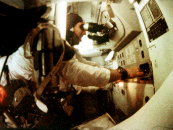
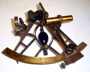
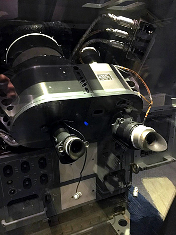
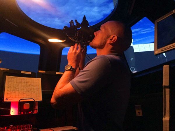
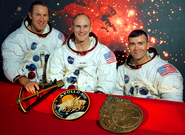

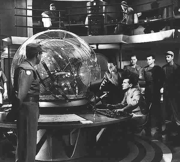
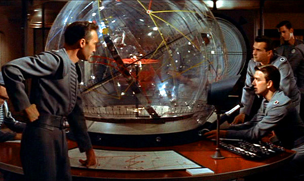
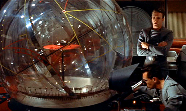
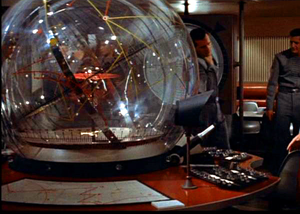
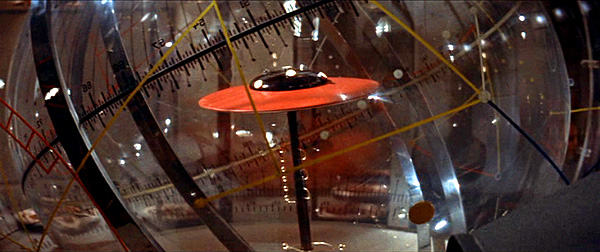
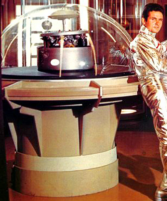
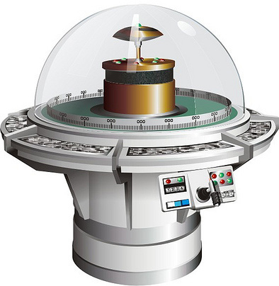
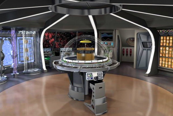


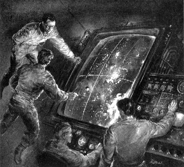


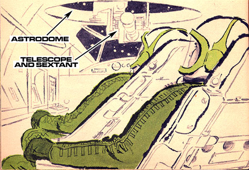
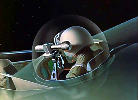
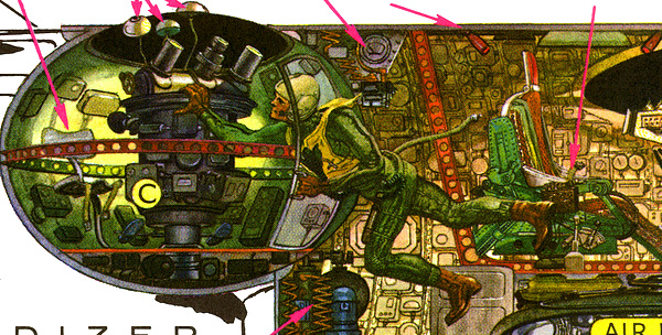
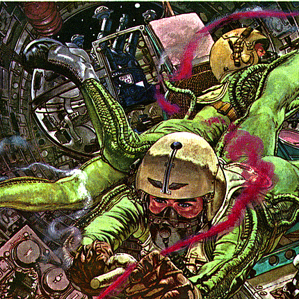
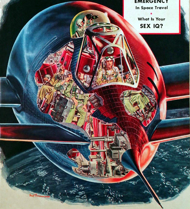
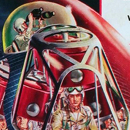
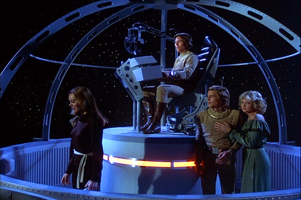
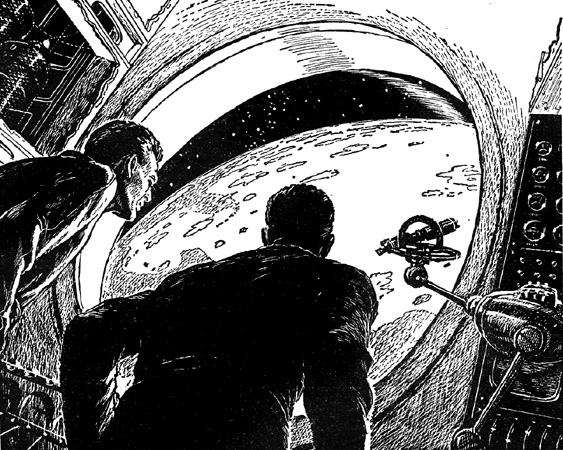
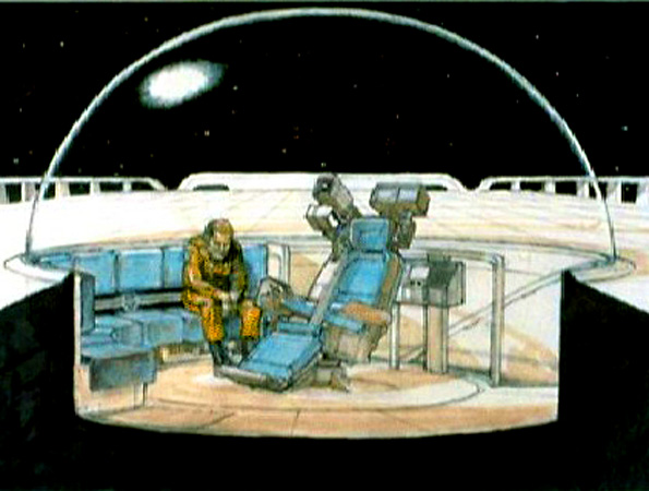

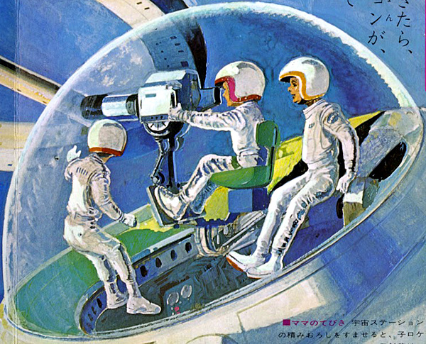

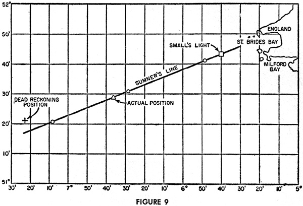
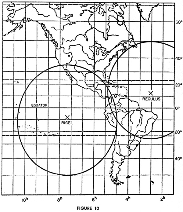
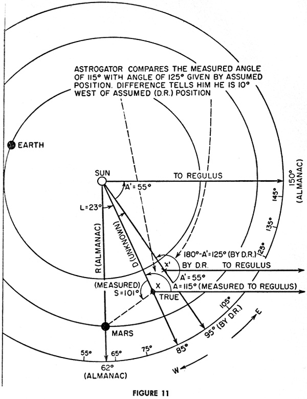


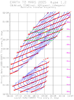
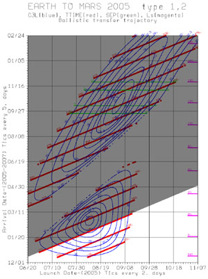
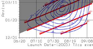
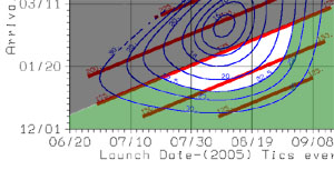
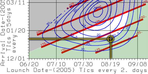

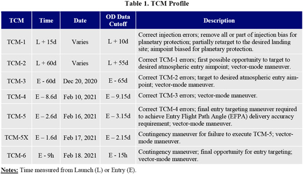

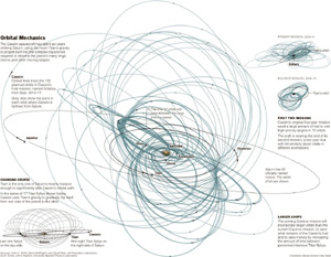

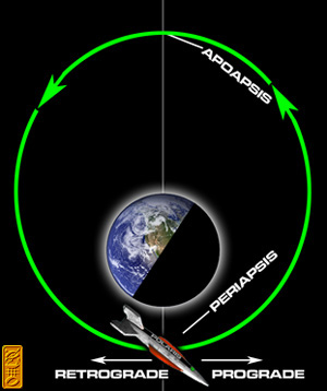
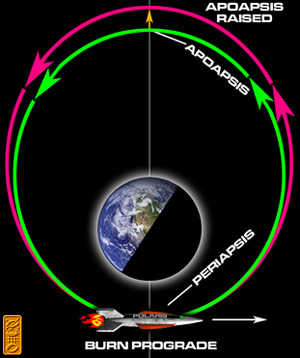
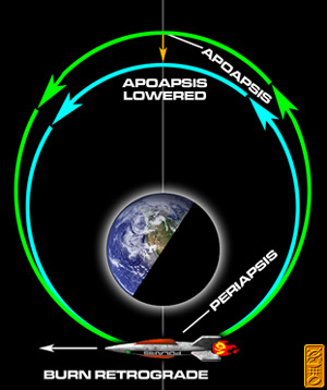
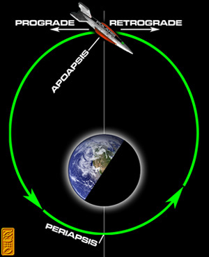
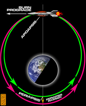
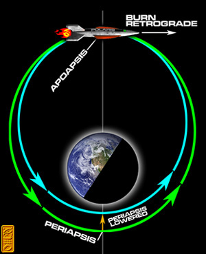
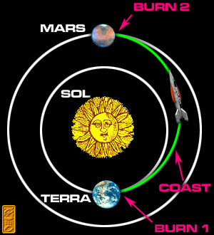

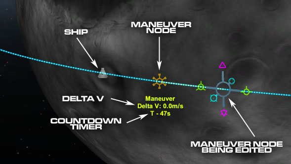
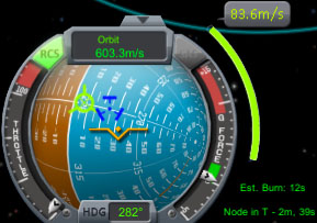
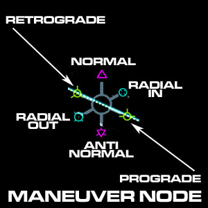
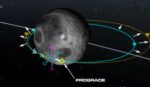
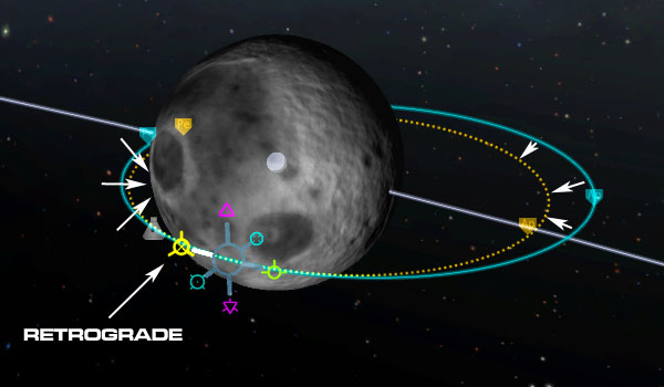
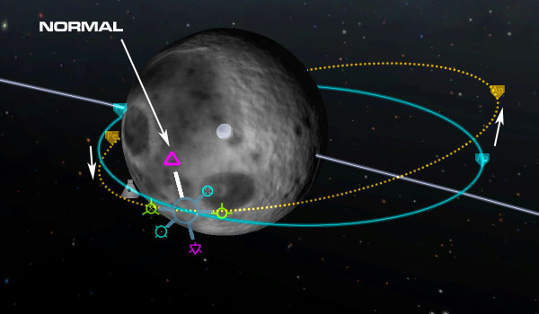
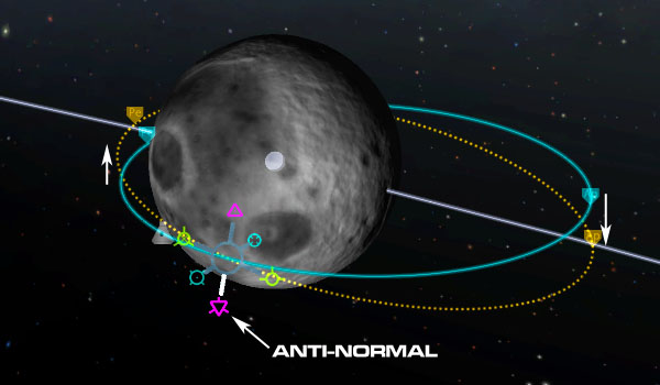
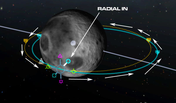
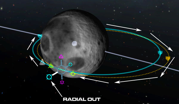


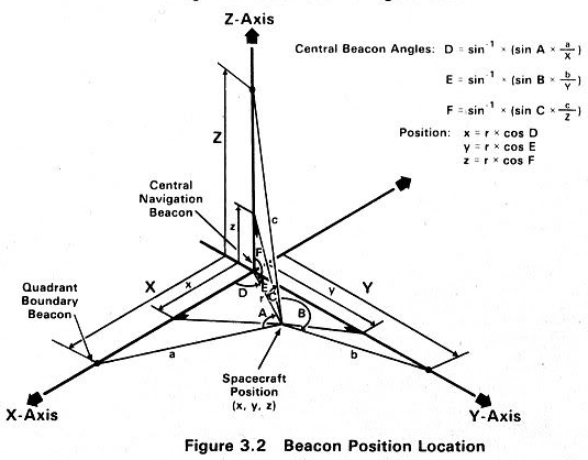

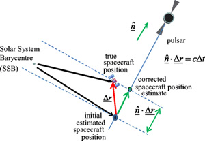
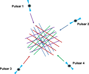
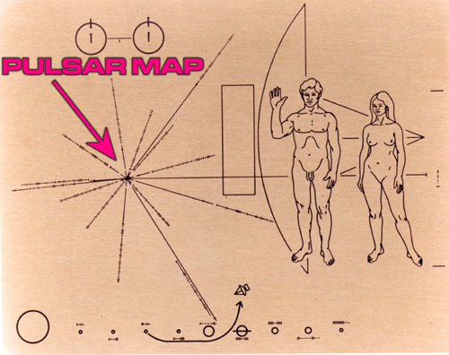
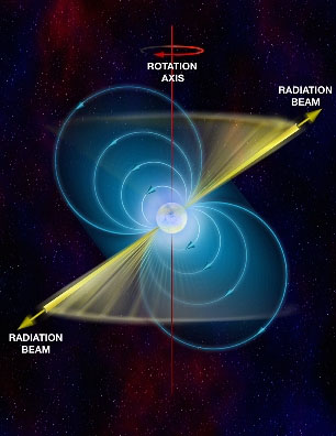
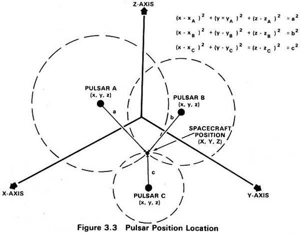
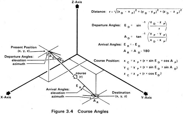


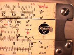

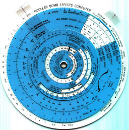
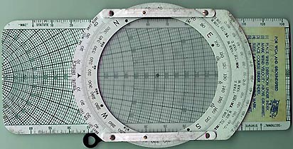


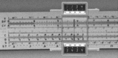

 . Standard disclaimer: I constructed this nomogram but I am not a rocket scientist. There may be errors. Use at your own risk.