Stories of the Stars: Aldebaran. Artwork by Frank Paul

Don't panic. This section is mainly for those who want the gory details of the utility program that follows. Please note that all the calculations here can be easily done with a pocket calculator, as long as it has SIN, COS, and square root keys. Biographical note: When I was in high school, I did these calculations with a calculator. In college, a friend (Jef Hamlin) showed me how to program the university computer to do the same tasks. That taste was enough to hook me on computers. So, if it wasn't for starmaps, I probably wouldn't be a computer programmer today, and you wouldn't have this webpage to read.
Ascension and Declination
Most astronomy reference books give stars "Right Ascension" and "Declination". This are sort of a cosmic Latitude and Longitude. Right Ascension is given as Hours, Minutes, and Seconds. Declination is given as Degrees, Minutes, and Seconds. Declination might be a negative number.

One of the closest sunlike stars is Tau Ceti (Gliese 71). Its Right Ascension is 01h41m45s, that is, 1 hour, 41 minutes, and 45 seconds. Tau Ceti's Declination is -16°12' that is, -16 degrees and 12 minutes.
Distance
Parallax in Arcsecs
Unfortunately, to plot said star on your map, you also need its distance, and this vital bit of info is often lacking. If you are lucky, the "parallax" will be given (If you want to know more about what parallax is, click here ). Divide 1 by the parallax ( in seconds of arc ) to convert it into distance in parsecs, that is:
Distance in Parsecs = 1 / Parallax
Distance in Light Years = Distance in Parsecs * 3.26
Note to non-computer programmers: In computer programming, "*" is the symbol for multiplication.
Tau Ceti's parallax is 0.277. Therefore, its distance is 3.61 parsecs or 11.77 light years.
Parallax in Milliarcsecs
WARNING! the above equation assumes that the parallax is in seconds of arc, or "arcsecs". Some catalogs give parallax in "mas", "milliarcsecs", or thousandths of arsecs. These include the Hipparcos and Sky2000 catalogs.
For them, the equation is:
Distance in Parsecs = 1000 / Parallax
(Thanks to Lon Miller for pointing this out, and Chris Lawson for simplifying the equation)
Negative Parallax
WARNING! in some catalogs, the parallax will be a negative number! Do not use these! Don't bother calculating the co-ordinates for this star at all because the data is bad.
The explaination is compilicated, but what it boils down to is that the software used to crunch numbers for the catalog will sometime generate a negative number if the parallax is vanishingly small. Bottom line is that a negative parallax means the star is really really far away.
You will find more than you probably want to know about the accuracy of parallax here.
For them, the equation is:
Distance in Parsecs = 1000 / Parallax
(Thanks to Lon Miller for pointing this out, and Chris Lawson for simplifying the equation)
Jordi Mas explained it this way:

The result of a "measurement" is a center point plus an error margin, sigma. If, for a certain star, the hipparcos catalogue means that parallax is center point 250 and sigma is 50, then that means, roughly, that we can be 70% sure that the true parallax is between 200 and 300.
The numbers 250 and 50 come from a lot of number-crunching applied to some dozens of observations of the satar; they are in the catalogue just as they came out from the computer. If in some case the parallax is -3 and the sigma is 50, this means, roughly, that according to the general rule there is a 70% chance that the true parallax is between -53 and + 47 ... the reducting software doesn't know that all parallaxes are positive, but we do, and we must interpret this result as "this star is likely very far away".
Of course, if the parrallax in the catalogue is `+3 and the sigma is 50 this doesn't mean that the actual distance is 1000/3; it still means that "this star is likely very far away".
Understand that very small parallaxes are highly unreliable; we'll have to wait for GAIA to measure the distance to the star.

Co-ordinates
From Degrees

Now, given the Right Ascension, Declination, and Distance, we are going to calculate the star's X,Y, and Z co-ordinates. These co-ords will be used when we plot our map. (They are called "Cartesian Co-ordinates", if anybody cares) First off, Right Ascension is given in terms of Hours, Minutes, and Seconds. Declination is given as Degrees, Minutes, and Seconds. Both of these have to be converted into Degrees, thusly:
PHI = ( RAHours * 15 ) + ( RAMinutes * 0.25 ) + ( RASeconds * 0.0041666 )
THETA = ( ABS(DECDegrees) + DECMinutes/60 + DECSeconds / 3600 ) * SIGN[DECDegrees]
RHO = (distance converted to scale units: light years,parsecs, or whatever)
where
- ABS[x] means "Absolute Value" of x, that is, without any negative sign
- SIGN[x] means the sign of x, positive or negative. (SIGN[23] = 1, SIGN[-17] = -1 )
If Decl is -16°12', then:
Theta = (16 + (12/60)) * -1 = -16.2
NOT Theta = (-16 + (12/60)) = -15.8
If Tau Ceti is at RA 1h41m45s, Dec -16°12m, Distance 3.61 parsecs, then PHI = 25.437497 degrees, THETA = -16.2 degrees, RHO = 3.61 parsecs.
From Decimal Degrees
Occasionally instead of the star data having Right Ascension and Declination in Hours (or Degrees), Minutes, and Seconds, the data will be in the form of a decimal degree. For example, instead of the Right Ascension being 21h44m34s it will be something like 21.7428. In this case use the following equations:
PHI = RADecimalDegree * 15
THETA = DECDecimalDegree
RHO = (distance converted to scale units: light years,parsecs, or whatever)
Note that whatever units you use for RHO will determine what units X,Y, and Z will be in. Be sure that all the distance information for a given batch of stars are in the same units, it won't work if some are in parsecs and others are in light years.
Putting It Together
Now comes the fun part.
RVECT = RHO * COS[ THETA ]
X = RVECT * COS[ PHI ]
Y = RVECT * SIN[ PHI ]
Z = RHO * SIN[ THETA ]
where
- COS[x] means "take the cosine of x".
- SIN[x] means "take the sine of x".
X, Y, and Z will be in the same units that RHO is in. RVECT stands for "radius vector", just in case you were wondering.
IMPORTANT!! Beware that most computer programming languages and spreadsheets want SIN[x] and COS[x] fed angles given in radians, not degrees. So you'll have to convert them. Multiply degrees by 0.0174532925 to convert them into radians. You do not have to convert to radians if you are doing your calculations with a slide rule, pocket calculator, the Windows Calculator app, or something like that. But nobody uses those anymore.
(actually I did use a pocket calculator when I was making my first 3D star map, but that was back in 1976. Took 15 minutes to calculate one star, and I had thousands to do. In college, a friend introduced me to mainframe computers. A simple program and it did the entire list in a fraction of a second. I immediately switched my major from Fine Arts to Computer Programming)
Why radians? Erik Max Francis says:
It's because radians are the only "natural" unit for calculating degrees in; they're defined in a dimensionless way such that an angle of 1 rad is such that the arc along the central angle is the same as the radius of the circle. When you're dealing with equations where the angles are all bound up in trigonometric functions (e.g., only appear as sin theta, etc.), then it doesn't matter mathematically, but if you have situations where they can creep out of the trigonometric functions (which you often find in calculus), then you absolutely must use radians or you will find the wrong answer.
Thanks Max, you're the first person who ever gave me the straight dope on that question.
COS[THETA] = COS[-16.2] = 0.960293685.
RVECT = RHO * COS[THETA] = 3.61 * 0.960293685 = 3.46666.
COS[PHI] = COS[25.437497] = 0.903054384. X = RVECT * COS(PHI) = 3.46666 * 0.903054384 = 3.13.
SIN[PHI] = SIN[25.437497] = 0.429526225. Y = RVECT * SIN(PHI) = 3.46666 * 0.429526225 = 1.49.
SIN[THETA] = SIN[-16.2] = -0.278991106. Z = RHO * SIN[THETA] = 3.61 * (-0.278991106) = -1.01.
Therefore, Tau Ceti is at 3.13, 1.49, -1.01. These units are in parsecs, since RHO was in parsecs. The X,Y,Z co-ords are always in the same units that RHO is in. If you want them in light years, remember that Parsecs * 3.26 = Light years, i.e., Tau Ceti would be at 10.20, 4.86, -3.29 in light year units.
You now are the proud owner of the star's X,Y,Z co-ords, in earth celestial co-ords. That is, the X-Y plane is parallel to the celestial equator.
Crafty Applications
Simple 2-D Plots
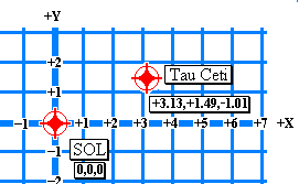
Whip out a piece of graph paper, put a dot at the center ( labeled "SOL, Earth" ), then draw a horizontal and vertical line through it. Locate the star's X and Y co-ords, and plot it. Write the Z co-ord next to it.
Please note that this can be a painless way to teach young people how to graph things on graph paper. If you happen to be a young person, I'm sure you can find a teacher who can teach you.
Here is a Microsoft Excel spreadsheet that will do the above calculations for you. Just duplicate enough rows for the stars you have.
Simple 3-D Plots
If you really want to go to town, make a framework, string threads vertically through each star plot, and glue a bead at the proper Z co-ord above or below the paper. You can get really fancy by using tiny lights or glow-in-the-dark paints and a black light. Fiber optics would work as well. There was a titanic version of this on display recently at the Smithsonian Air and Space museum.
Here is a great project from the NASA Institute for Advanced Concepts. They are detailed instructions on how to make a little 10 centimeter square 3-D starmap of the 15 nearest stars to the Sun, using foam core, wire and pins. It is a great project for students, and will look nice on your desk.
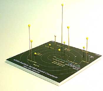
3-D map project from the NASA Institute for Advanced Concepts. 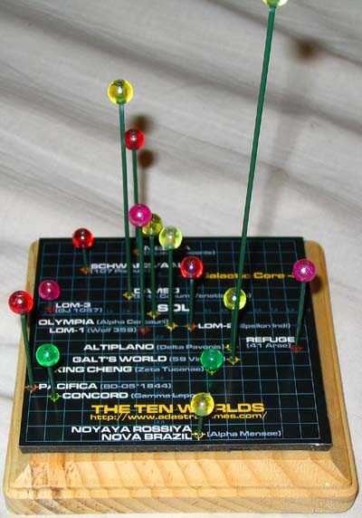
3-D map based on the Attack Vector: Tactical universe.
To the above right is a map I made using the NASA instructions, but using my own starmap. Its a map of the colonized stars from Ken Burnside's Attack Vector: Tactical universe. I used 8mm beads color coded by spectral class on lengths of thick straight florist wire, both from a local arts and craft store. The base image was from a *.pdf file output from a Python program I wrote (using the ReportLab toolkit), the file was tweeked in Adobe Illustrator. It was printed with an ink-jet printer on photo glossy paper.
Fancier 3-D Plots
If you want a custom made 3-d starmap, go to Jeffrey Carl's Stellarium web site and order one. He's not cheap, but the results are worth it. He made the 3-d starmap on display at the Smithsonian.
Ansible Technologies Ltd. construct real time space simulators, digital planetariums, and display technology for schools, universities, observatories, and museums.
If a Stellarium or Ansible is out of your price range, look into Lady Bathsheba Grossman's marvelous star-cubes. They are three inch cubes of glass, laser-etched with all the stars within five parsecs of the sun.

Stellarium by Jeffrey Carl. 
Digital planetarium by Ansible Technologies Ltd. 
Star-cube by Bathsheba Grossman.
Other 3-D Plots
I've also heard about 3-d starmaps made by embedding beads in castable polymer resin (the kind they make those cheezy paperweights out of, the ones with sea-shells, dried starfish, and letters spelling out "SOUVENIR OF ATLANTIC CITY"). A quick and dirty starmap can be made with sticks of appropriate heights stuck into a styrofoam base, with little styrofoam balls attached to the tops. One could also draw "stereo pairs", two pictures of the starmap that would appear in 3-d when looked through a stereo viewer. The possibilites are endless.
George Margaris has created a Flash 3-d starmap.
Don Ware has created VRML 3-d starmap.
Theta-Phi-Rho?
There is an explanation of galactic Theta-Phi-Rho co-ordinates in Issac Asimov's THE STARS LIKE DUST. Rho is the distance from the Galactic Center in parsecs. Theta is the angular separation, along the plane of the Galaxy from the Standard Galactic Baseline (the line, that is, which connects the Galactic Center and Earth). Phi is the angular separation from the Baseline in a plane perpendicular to the plane of the Galaxy. Theta and Phi are expressed in radians.